You are here: Home > Network List > TA - USArray Transportable Network (new EarthScope stations) Stations List
> Station B18K Kokolik River, AK, USA > Earthquake Result Viewer
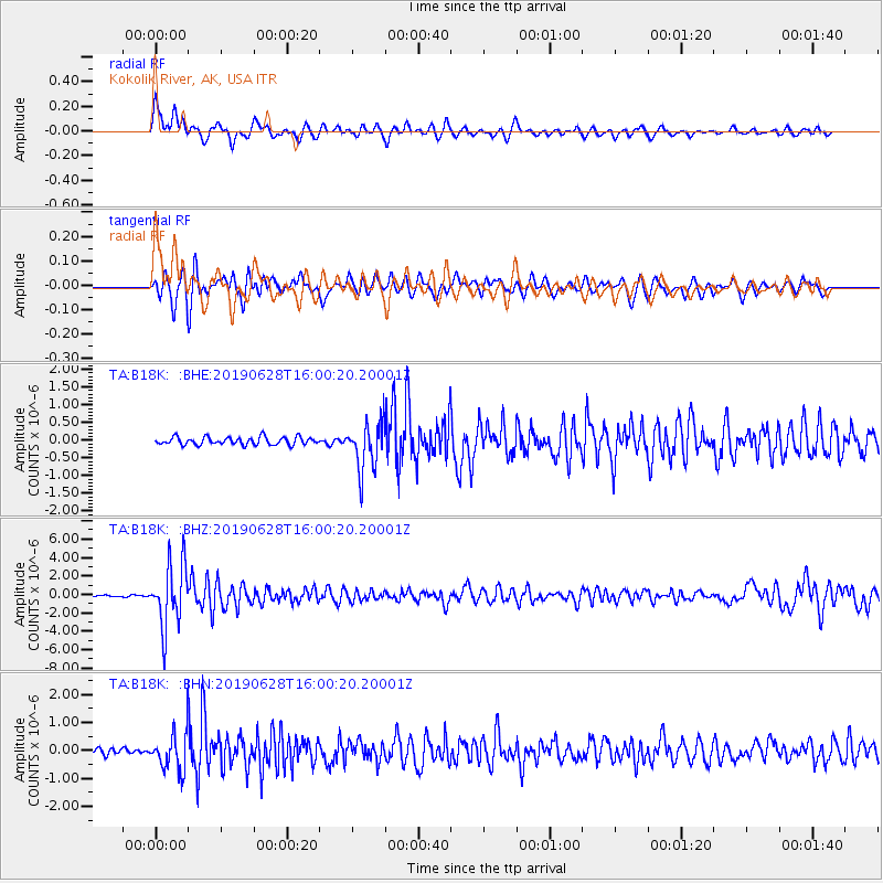
B18K Kokolik River, AK, USA - Earthquake Result Viewer
*The percent match for this event was below the threshold and hence no stack was calculated.
| Earthquake location: |
Mariana Islands |
| Earthquake latitude/longitude: |
19.9/144.3 |
| Earthquake time(UTC): |
2019/06/28 (179) 15:51:31 GMT |
| Earthquake Depth: |
410 km |
| Earthquake Magnitude: |
6.4 Mww |
| Earthquake Catalog/Contributor: |
NEIC PDE/us |
|
| Network: |
TA USArray Transportable Network (new EarthScope stations) |
| Station: |
B18K Kokolik River, AK, USA |
| Lat/Lon: |
69.36 N/161.80 W |
| Elevation: |
222 m |
|
| Distance: |
59.2 deg |
| Az: |
19.473 deg |
| Baz: |
242.272 deg |
| Ray Param: |
$rayparam |
*The percent match for this event was below the threshold and hence was not used in the summary stack. |
|
| Radial Match: |
79.38948 % |
| Radial Bump: |
400 |
| Transverse Match: |
74.487076 % |
| Transverse Bump: |
400 |
| SOD ConfigId: |
19053131 |
| Insert Time: |
2019-07-27 14:05:21.937 +0000 |
| GWidth: |
2.5 |
| Max Bumps: |
400 |
| Tol: |
0.001 |
|
Signal To Noise
| Channel | StoN | STA | LTA |
| TA:B18K: :BHZ:20190628T16:00:20.20001Z | 22.771101 | 3.3874182E-6 | 1.4875951E-7 |
| TA:B18K: :BHN:20190628T16:00:20.20001Z | 4.50331 | 6.442347E-7 | 1.4305805E-7 |
| TA:B18K: :BHE:20190628T16:00:20.20001Z | 6.26875 | 6.737703E-7 | 1.0748081E-7 |
| Arrivals |
| Ps | |
| PpPs | |
| PsPs/PpSs | |


