You are here: Home > Network List > TA - USArray Transportable Network (new EarthScope stations) Stations List
> Station D19K Kuna River, AK, USA > Earthquake Result Viewer
D19K Kuna River, AK, USA - Earthquake Result Viewer
| Earthquake location: |
Mariana Islands |
| Earthquake latitude/longitude: |
19.9/144.3 |
| Earthquake time(UTC): |
2019/06/28 (179) 15:51:31 GMT |
| Earthquake Depth: |
410 km |
| Earthquake Magnitude: |
6.4 Mww |
| Earthquake Catalog/Contributor: |
NEIC PDE/us |
|
| Network: |
TA USArray Transportable Network (new EarthScope stations) |
| Station: |
D19K Kuna River, AK, USA |
| Lat/Lon: |
68.49 N/158.12 W |
| Elevation: |
671 m |
|
| Distance: |
60.0 deg |
| Az: |
21.054 deg |
| Baz: |
246.51 deg |
| Ray Param: |
0.06034547 |
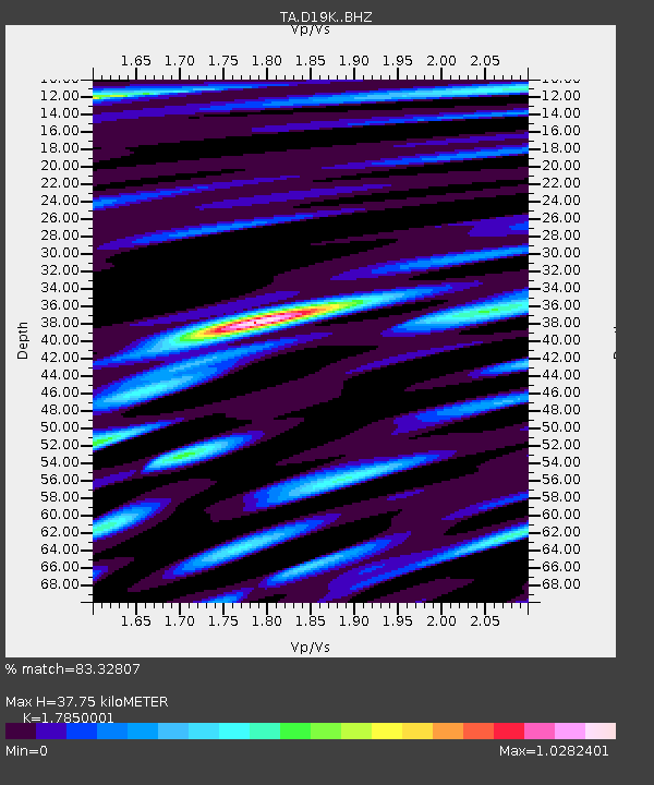
| Estimated Moho Depth: |
37.75 km |
| Estimated Crust Vp/Vs: |
1.79 |
| Assumed Crust Vp: |
6.221 km/s |
| Estimated Crust Vs: |
3.485 km/s |
| Estimated Crust Poisson's Ratio: |
0.27 |
|
| Radial Match: |
83.32807 % |
| Radial Bump: |
400 |
| Transverse Match: |
75.1033 % |
| Transverse Bump: |
400 |
| SOD ConfigId: |
19053131 |
| Insert Time: |
2019-07-27 14:05:31.489 +0000 |
| GWidth: |
2.5 |
| Max Bumps: |
400 |
| Tol: |
0.001 |
|

Signal To Noise
| Channel | StoN | STA | LTA |
| TA:D19K: :BHZ:20190628T16:00:25.749998Z | 36.856388 | 2.6142686E-6 | 7.093122E-8 |
| TA:D19K: :BHN:20190628T16:00:25.749998Z | 12.784636 | 4.3219828E-7 | 3.3806067E-8 |
| TA:D19K: :BHE:20190628T16:00:25.749998Z | 14.565248 | 8.175464E-7 | 5.6129934E-8 |
| Arrivals |
| Ps | 5.0 SECOND |
| PpPs | 16 SECOND |
| PsPs/PpSs | 21 SECOND |


