You are here: Home > Network List > TA - USArray Transportable Network (new EarthScope stations) Stations List
> Station N12A Clover Valley, Wells, NV, USA > Earthquake Result Viewer
N12A Clover Valley, Wells, NV, USA - Earthquake Result Viewer
| Earthquake location: |
Mariana Islands |
| Earthquake latitude/longitude: |
21.0/144.7 |
| Earthquake time(UTC): |
2007/01/30 (030) 21:37:45 GMT |
| Earthquake Depth: |
30 km |
| Earthquake Magnitude: |
6.3 MB, 6.5 MS, 6.6 MW, 6.5 MW |
| Earthquake Catalog/Contributor: |
WHDF/NEIC |
|
| Network: |
TA USArray Transportable Network (new EarthScope stations) |
| Station: |
N12A Clover Valley, Wells, NV, USA |
| Lat/Lon: |
40.85 N/115.04 W |
| Elevation: |
1786 m |
|
| Distance: |
83.9 deg |
| Az: |
48.645 deg |
| Baz: |
292.378 deg |
| Ray Param: |
0.04579647 |
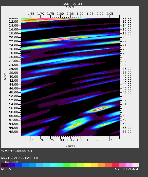
| Estimated Moho Depth: |
56.25 km |
| Estimated Crust Vp/Vs: |
2.00 |
| Assumed Crust Vp: |
6.276 km/s |
| Estimated Crust Vs: |
3.146 km/s |
| Estimated Crust Poisson's Ratio: |
0.33 |
|
| Radial Match: |
89.44748 % |
| Radial Bump: |
400 |
| Transverse Match: |
84.16349 % |
| Transverse Bump: |
400 |
| SOD ConfigId: |
2564 |
| Insert Time: |
2010-03-07 01:46:46.430 +0000 |
| GWidth: |
2.5 |
| Max Bumps: |
400 |
| Tol: |
0.001 |
|
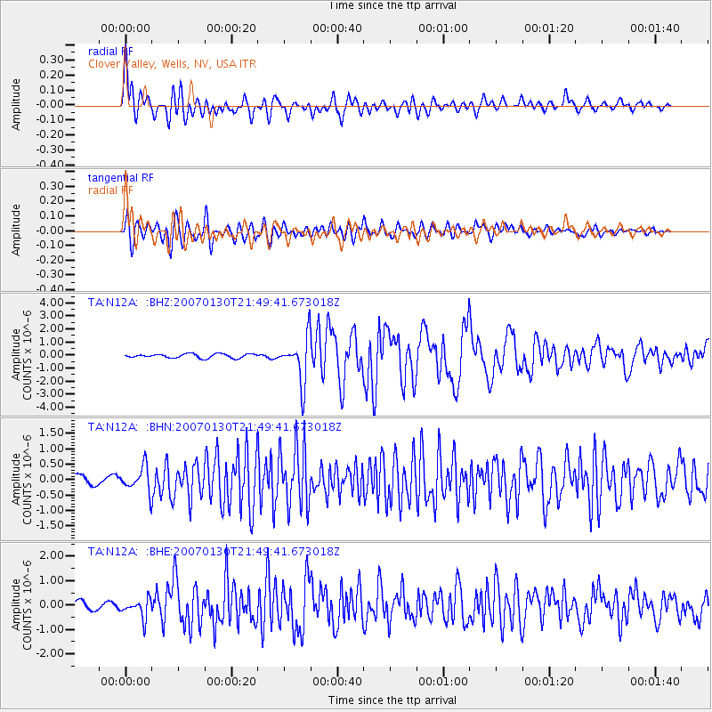
Signal To Noise
| Channel | StoN | STA | LTA |
| TA:N12A: :BHN:20070130T21:49:41.673018Z | 2.0161543 | 4.0760992E-7 | 2.0217199E-7 |
| TA:N12A: :BHE:20070130T21:49:41.673018Z | 2.0749981 | 3.9025042E-7 | 1.8807266E-7 |
| TA:N12A: :BHZ:20070130T21:49:41.673018Z | 11.848783 | 1.8023493E-6 | 1.521126E-7 |
| Arrivals |
| Ps | 9.1 SECOND |
| PpPs | 26 SECOND |
| PsPs/PpSs | 35 SECOND |


