You are here: Home > Network List > TA - USArray Transportable Network (new EarthScope stations) Stations List
> Station F18K Selawik, AK, USA > Earthquake Result Viewer
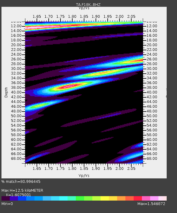
F18K Selawik, AK, USA - Earthquake Result Viewer
| Earthquake location: |
Mariana Islands |
| Earthquake latitude/longitude: |
19.9/144.3 |
| Earthquake time(UTC): |
2019/06/28 (179) 15:51:31 GMT |
| Earthquake Depth: |
410 km |
| Earthquake Magnitude: |
6.4 Mww |
| Earthquake Catalog/Contributor: |
NEIC PDE/us |
|
| Network: |
TA USArray Transportable Network (new EarthScope stations) |
| Station: |
F18K Selawik, AK, USA |
| Lat/Lon: |
66.60 N/159.65 W |
| Elevation: |
27 m |
|
| Distance: |
58.7 deg |
| Az: |
22.803 deg |
| Baz: |
245.983 deg |
| Ray Param: |
0.061164893 |
| Estimated Moho Depth: |
12.5 km |
| Estimated Crust Vp/Vs: |
1.61 |
| Assumed Crust Vp: |
6.577 km/s |
| Estimated Crust Vs: |
4.091 km/s |
| Estimated Crust Poisson's Ratio: |
0.18 |
|
| Radial Match: |
80.996445 % |
| Radial Bump: |
400 |
| Transverse Match: |
69.38208 % |
| Transverse Bump: |
400 |
| SOD ConfigId: |
19053131 |
| Insert Time: |
2019-07-27 14:05:45.685 +0000 |
| GWidth: |
2.5 |
| Max Bumps: |
400 |
| Tol: |
0.001 |
|

Signal To Noise
| Channel | StoN | STA | LTA |
| TA:F18K: :BHZ:20190628T16:00:16.924986Z | 33.090733 | 1.971742E-6 | 5.9585922E-8 |
| TA:F18K: :BHN:20190628T16:00:16.924986Z | 3.4135065 | 3.2478644E-7 | 9.5147456E-8 |
| TA:F18K: :BHE:20190628T16:00:16.924986Z | 6.494298 | 7.4877033E-7 | 1.1529658E-7 |
| Arrivals |
| Ps | 1.2 SECOND |
| PpPs | 4.7 SECOND |
| PsPs/PpSs | 5.9 SECOND |


