You are here: Home > Network List > TA - USArray Transportable Network (new EarthScope stations) Stations List
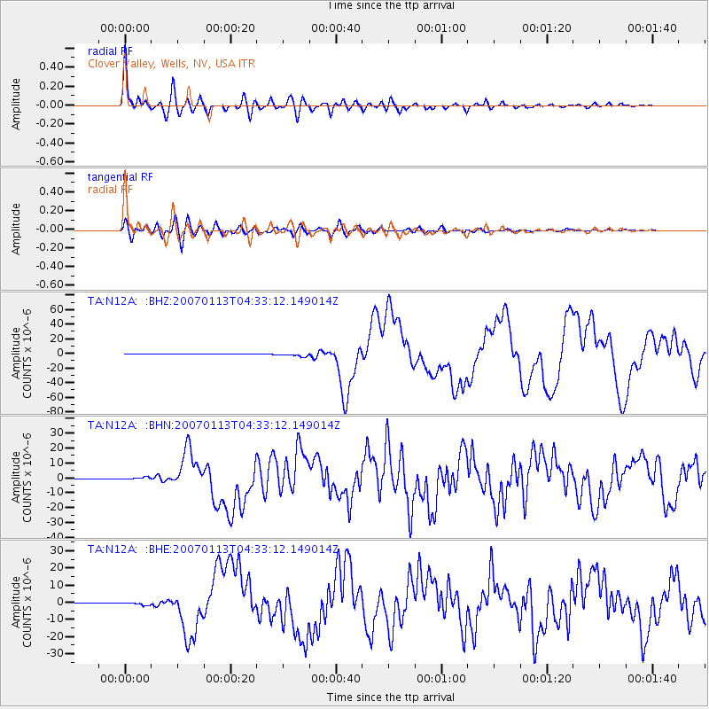
> Station N12A Clover Valley, Wells, NV, USA > Earthquake Result Viewer
N12A Clover Valley, Wells, NV, USA - Earthquake Result Viewer
| Earthquake location: |
East Of Kuril Islands |
| Earthquake latitude/longitude: |
46.2/154.5 |
| Earthquake time(UTC): |
2007/01/13 (013) 04:23:21 GMT |
| Earthquake Depth: |
10 km |
| Earthquake Magnitude: |
7.3 MB, 8.2 MS, 8.1 MW, 7.9 MW |
| Earthquake Catalog/Contributor: |
WHDF/NEIC |
|
| Network: |
TA USArray Transportable Network (new EarthScope stations) |
| Station: |
N12A Clover Valley, Wells, NV, USA |
| Lat/Lon: |
40.85 N/115.04 W |
| Elevation: |
1786 m |
|
| Distance: |
62.3 deg |
| Az: |
58.966 deg |
| Baz: |
308.376 deg |
| Ray Param: |
0.060328636 |
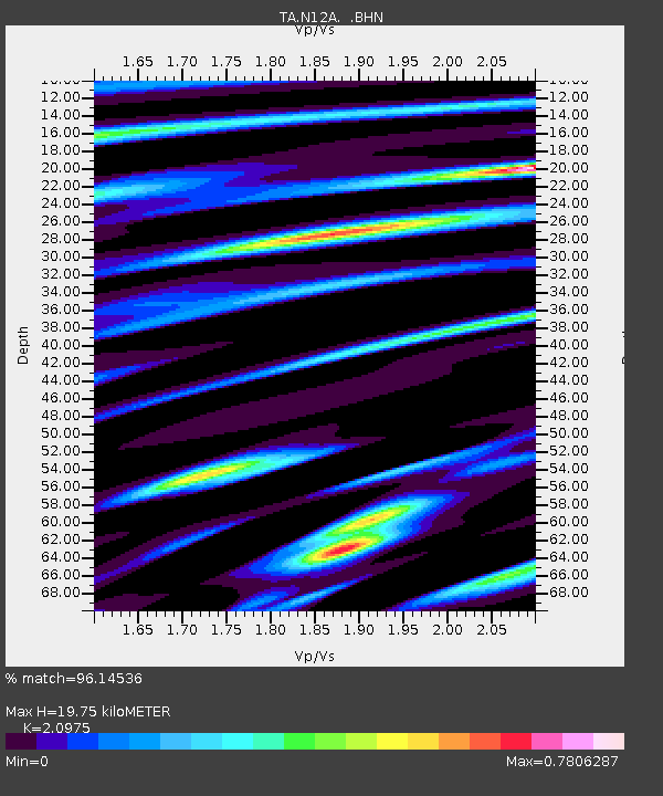
| Estimated Moho Depth: |
19.75 km |
| Estimated Crust Vp/Vs: |
2.10 |
| Assumed Crust Vp: |
6.276 km/s |
| Estimated Crust Vs: |
2.992 km/s |
| Estimated Crust Poisson's Ratio: |
0.35 |
|
| Radial Match: |
96.14536 % |
| Radial Bump: |
400 |
| Transverse Match: |
83.36083 % |
| Transverse Bump: |
400 |
| SOD ConfigId: |
2564 |
| Insert Time: |
2010-03-07 01:46:48.135 +0000 |
| GWidth: |
2.5 |
| Max Bumps: |
400 |
| Tol: |
0.001 |
|
Signal To Noise
| Channel | StoN | STA | LTA |
| TA:N12A: :BHN:20070113T04:33:12.149014Z | 5.3730755 | 7.075402E-7 | 1.3168254E-7 |
| TA:N12A: :BHE:20070113T04:33:12.149014Z | 7.9004865 | 8.5024993E-7 | 1.0761995E-7 |
| TA:N12A: :BHZ:20070113T04:33:12.149014Z | 8.58334 | 2.1936992E-6 | 2.5557642E-7 |
| Arrivals |
| Ps | 3.6 SECOND |
| PpPs | 9.4 SECOND |
| PsPs/PpSs | 13 SECOND |


