You are here: Home > Network List > PF - Volcanologic Network of Piton de Fournaise-OVPF Stations List
> Station PRA Puys Ramond > Earthquake Result Viewer
PRA Puys Ramond - Earthquake Result Viewer
| Earthquake location: |
New Ireland Region, P.N.G. |
| Earthquake latitude/longitude: |
-5.7/153.9 |
| Earthquake time(UTC): |
2016/12/17 (352) 11:27:41 GMT |
| Earthquake Depth: |
40 km |
| Earthquake Magnitude: |
6.0 mb |
| Earthquake Catalog/Contributor: |
NEIC PDE/us |
|
| Network: |
PF Volcanologic Network of Piton de Fournaise-OVPF |
| Station: |
PRA Puys Ramond |
| Lat/Lon: |
21.29 S/55.71 E |
| Elevation: |
2009 m |
|
| Distance: |
95.6 deg |
| Az: |
248.026 deg |
| Baz: |
98.288 deg |
| Ray Param: |
0.04072585 |
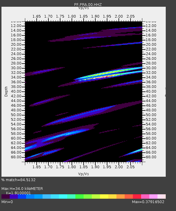
| Estimated Moho Depth: |
34.0 km |
| Estimated Crust Vp/Vs: |
1.91 |
| Assumed Crust Vp: |
4.73 km/s |
| Estimated Crust Vs: |
2.476 km/s |
| Estimated Crust Poisson's Ratio: |
0.31 |
|
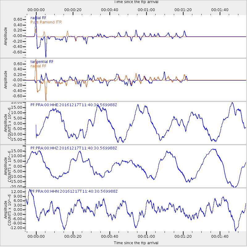
| Radial Match: |
84.5132 % |
| Radial Bump: |
400 |
| Transverse Match: |
80.72524 % |
| Transverse Bump: |
400 |
| SOD ConfigId: |
1894071 |
| Insert Time: |
2016-12-31 11:32:27.758 +0000 |
| GWidth: |
2.5 |
| Max Bumps: |
400 |
| Tol: |
0.001 |
|
Signal To Noise
| Channel | StoN | STA | LTA |
| PF:PRA:00:HHZ:20161217T11:40:30.569988Z | 1.7607151 | 1.4557731E-5 | 8.268079E-6 |
| PF:PRA:00:HHN:20161217T11:40:30.569988Z | 0.4785461 | 3.1328996E-6 | 6.5467034E-6 |
| PF:PRA:00:HHE:20161217T11:40:30.569988Z | 1.1436099 | 1.0983733E-5 | 9.604441E-6 |
| Arrivals |
| Ps | 6.6 SECOND |
| PpPs | 21 SECOND |
| PsPs/PpSs | 27 SECOND |


