You are here: Home > Network List > TA - USArray Transportable Network (new EarthScope stations) Stations List
> Station G26K Porcupine River, AK, USA > Earthquake Result Viewer
G26K Porcupine River, AK, USA - Earthquake Result Viewer
| Earthquake location: |
Mariana Islands |
| Earthquake latitude/longitude: |
19.9/144.3 |
| Earthquake time(UTC): |
2019/06/28 (179) 15:51:31 GMT |
| Earthquake Depth: |
410 km |
| Earthquake Magnitude: |
6.4 Mww |
| Earthquake Catalog/Contributor: |
NEIC PDE/us |
|
| Network: |
TA USArray Transportable Network (new EarthScope stations) |
| Station: |
G26K Porcupine River, AK, USA |
| Lat/Lon: |
66.95 N/143.78 W |
| Elevation: |
180 m |
|
| Distance: |
64.8 deg |
| Az: |
24.428 deg |
| Baz: |
261.333 deg |
| Ray Param: |
0.057297446 |
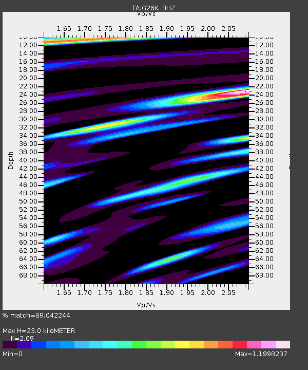
| Estimated Moho Depth: |
23.0 km |
| Estimated Crust Vp/Vs: |
2.09 |
| Assumed Crust Vp: |
6.577 km/s |
| Estimated Crust Vs: |
3.147 km/s |
| Estimated Crust Poisson's Ratio: |
0.35 |
|
| Radial Match: |
89.042244 % |
| Radial Bump: |
375 |
| Transverse Match: |
81.032646 % |
| Transverse Bump: |
400 |
| SOD ConfigId: |
19053131 |
| Insert Time: |
2019-07-27 14:05:56.427 +0000 |
| GWidth: |
2.5 |
| Max Bumps: |
400 |
| Tol: |
0.001 |
|

Signal To Noise
| Channel | StoN | STA | LTA |
| TA:G26K: :BHZ:20190628T16:00:57.099974Z | 37.541237 | 2.2134197E-6 | 5.8959692E-8 |
| TA:G26K: :BHN:20190628T16:00:57.099974Z | 15.969116 | 9.3650755E-7 | 5.8644922E-8 |
| TA:G26K: :BHE:20190628T16:00:57.099974Z | 28.174406 | 1.0949439E-6 | 3.886307E-8 |
| Arrivals |
| Ps | 3.9 SECOND |
| PpPs | 10 SECOND |
| PsPs/PpSs | 14 SECOND |


