You are here: Home > Network List > TA - USArray Transportable Network (new EarthScope stations) Stations List
> Station H20K Anotleneega Mountain, AK, USA > Earthquake Result Viewer
H20K Anotleneega Mountain, AK, USA - Earthquake Result Viewer
| Earthquake location: |
Mariana Islands |
| Earthquake latitude/longitude: |
19.9/144.3 |
| Earthquake time(UTC): |
2019/06/28 (179) 15:51:31 GMT |
| Earthquake Depth: |
410 km |
| Earthquake Magnitude: |
6.4 Mww |
| Earthquake Catalog/Contributor: |
NEIC PDE/us |
|
| Network: |
TA USArray Transportable Network (new EarthScope stations) |
| Station: |
H20K Anotleneega Mountain, AK, USA |
| Lat/Lon: |
65.49 N/154.88 W |
| Elevation: |
514 m |
|
| Distance: |
60.1 deg |
| Az: |
24.829 deg |
| Baz: |
251.37 deg |
| Ray Param: |
0.06027955 |
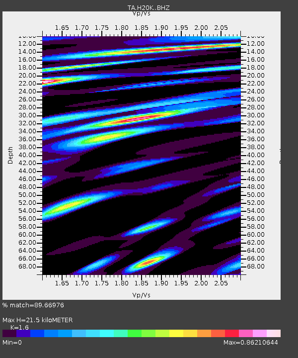
| Estimated Moho Depth: |
21.5 km |
| Estimated Crust Vp/Vs: |
1.60 |
| Assumed Crust Vp: |
6.566 km/s |
| Estimated Crust Vs: |
4.104 km/s |
| Estimated Crust Poisson's Ratio: |
0.18 |
|
| Radial Match: |
89.66976 % |
| Radial Bump: |
400 |
| Transverse Match: |
66.694595 % |
| Transverse Bump: |
400 |
| SOD ConfigId: |
19053131 |
| Insert Time: |
2019-07-27 14:06:00.925 +0000 |
| GWidth: |
2.5 |
| Max Bumps: |
400 |
| Tol: |
0.001 |
|

Signal To Noise
| Channel | StoN | STA | LTA |
| TA:H20K: :BHZ:20190628T16:00:26.424986Z | 41.15013 | 1.8363114E-6 | 4.4624677E-8 |
| TA:H20K: :BHN:20190628T16:00:26.424986Z | 12.053448 | 4.7643104E-7 | 3.9526533E-8 |
| TA:H20K: :BHE:20190628T16:00:26.424986Z | 16.765356 | 7.3940424E-7 | 4.4103107E-8 |
| Arrivals |
| Ps | 2.1 SECOND |
| PpPs | 8.1 SECOND |
| PsPs/PpSs | 10 SECOND |


