You are here: Home > Network List > TA - USArray Transportable Network (new EarthScope stations) Stations List
> Station J19K Poorman, AK, USA > Earthquake Result Viewer
J19K Poorman, AK, USA - Earthquake Result Viewer
| Earthquake location: |
Mariana Islands |
| Earthquake latitude/longitude: |
19.9/144.3 |
| Earthquake time(UTC): |
2019/06/28 (179) 15:51:31 GMT |
| Earthquake Depth: |
410 km |
| Earthquake Magnitude: |
6.4 Mww |
| Earthquake Catalog/Contributor: |
NEIC PDE/us |
|
| Network: |
TA USArray Transportable Network (new EarthScope stations) |
| Station: |
J19K Poorman, AK, USA |
| Lat/Lon: |
63.99 N/155.62 W |
| Elevation: |
389 m |
|
| Distance: |
59.3 deg |
| Az: |
26.364 deg |
| Baz: |
251.475 deg |
| Ray Param: |
0.06076901 |
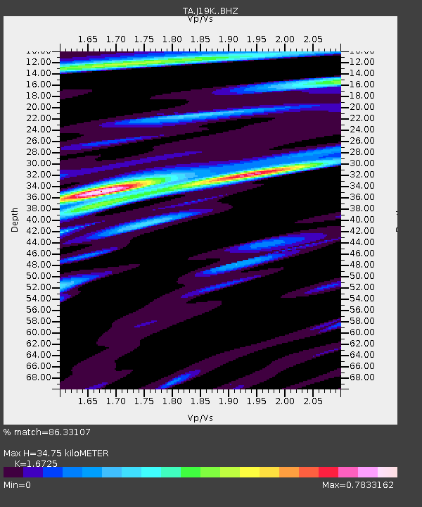
| Estimated Moho Depth: |
34.75 km |
| Estimated Crust Vp/Vs: |
1.67 |
| Assumed Crust Vp: |
6.438 km/s |
| Estimated Crust Vs: |
3.849 km/s |
| Estimated Crust Poisson's Ratio: |
0.22 |
|
| Radial Match: |
86.33107 % |
| Radial Bump: |
400 |
| Transverse Match: |
69.948906 % |
| Transverse Bump: |
400 |
| SOD ConfigId: |
19053131 |
| Insert Time: |
2019-07-27 14:06:16.148 +0000 |
| GWidth: |
2.5 |
| Max Bumps: |
400 |
| Tol: |
0.001 |
|

Signal To Noise
| Channel | StoN | STA | LTA |
| TA:J19K: :BHZ:20190628T16:00:21.20001Z | 29.663925 | 1.6270232E-6 | 5.484855E-8 |
| TA:J19K: :BHN:20190628T16:00:21.20001Z | 8.391315 | 3.3749538E-7 | 4.0219604E-8 |
| TA:J19K: :BHE:20190628T16:00:21.20001Z | 16.352243 | 7.146685E-7 | 4.3704617E-8 |
| Arrivals |
| Ps | 3.8 SECOND |
| PpPs | 14 SECOND |
| PsPs/PpSs | 18 SECOND |


