You are here: Home > Network List > TA - USArray Transportable Network (new EarthScope stations) Stations List
> Station M14K Bethel, AK, USA > Earthquake Result Viewer
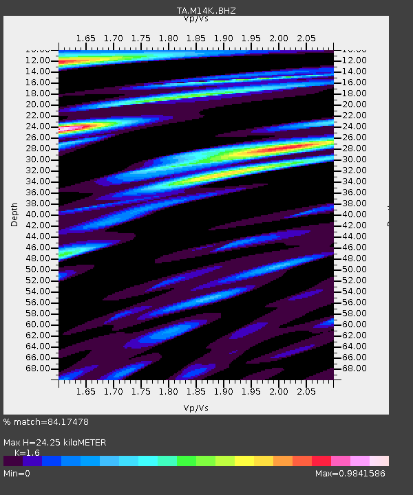
M14K Bethel, AK, USA - Earthquake Result Viewer
| Earthquake location: |
Mariana Islands |
| Earthquake latitude/longitude: |
19.9/144.3 |
| Earthquake time(UTC): |
2019/06/28 (179) 15:51:31 GMT |
| Earthquake Depth: |
410 km |
| Earthquake Magnitude: |
6.4 Mww |
| Earthquake Catalog/Contributor: |
NEIC PDE/us |
|
| Network: |
TA USArray Transportable Network (new EarthScope stations) |
| Station: |
M14K Bethel, AK, USA |
| Lat/Lon: |
60.75 N/161.96 W |
| Elevation: |
19 m |
|
| Distance: |
55.4 deg |
| Az: |
28.735 deg |
| Baz: |
247.144 deg |
| Ray Param: |
0.06324562 |
| Estimated Moho Depth: |
24.25 km |
| Estimated Crust Vp/Vs: |
1.60 |
| Assumed Crust Vp: |
6.182 km/s |
| Estimated Crust Vs: |
3.864 km/s |
| Estimated Crust Poisson's Ratio: |
0.18 |
|
| Radial Match: |
84.17478 % |
| Radial Bump: |
335 |
| Transverse Match: |
75.12659 % |
| Transverse Bump: |
394 |
| SOD ConfigId: |
19053131 |
| Insert Time: |
2019-07-27 14:06:29.848 +0000 |
| GWidth: |
2.5 |
| Max Bumps: |
400 |
| Tol: |
0.001 |
|

Signal To Noise
| Channel | StoN | STA | LTA |
| TA:M14K: :BHZ:20190628T15:59:54.299986Z | 23.855097 | 2.9811429E-6 | 1.2496879E-7 |
| TA:M14K: :BHN:20190628T15:59:54.299986Z | 7.6871686 | 1.0886905E-6 | 1.4162438E-7 |
| TA:M14K: :BHE:20190628T15:59:54.299986Z | 7.576019 | 1.1837584E-6 | 1.5625072E-7 |
| Arrivals |
| Ps | 2.5 SECOND |
| PpPs | 9.7 SECOND |
| PsPs/PpSs | 12 SECOND |


