You are here: Home > Network List > TA - USArray Transportable Network (new EarthScope stations) Stations List
> Station N12A Clover Valley, Wells, NV, USA > Earthquake Result Viewer
N12A Clover Valley, Wells, NV, USA - Earthquake Result Viewer
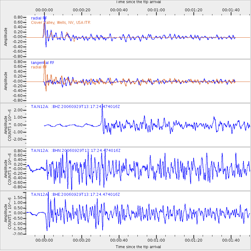
| Earthquake location: |
Trinidad |
| Earthquake latitude/longitude: |
10.9/-61.8 |
| Earthquake time(UTC): |
2006/09/29 (272) 13:08:26 GMT |
| Earthquake Depth: |
53 km |
| Earthquake Magnitude: |
5.9 MB, 5.4 MS, 6.1 MW, 6.0 MW |
| Earthquake Catalog/Contributor: |
WHDF/NEIC |
|
| Network: |
TA USArray Transportable Network (new EarthScope stations) |
| Station: |
N12A Clover Valley, Wells, NV, USA |
| Lat/Lon: |
40.85 N/115.04 W |
| Elevation: |
1786 m |
|
| Distance: |
55.4 deg |
| Az: |
312.389 deg |
| Baz: |
106.982 deg |
| Ray Param: |
0.06467791 |
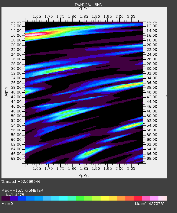
| Estimated Moho Depth: |
15.5 km |
| Estimated Crust Vp/Vs: |
1.63 |
| Assumed Crust Vp: |
6.276 km/s |
| Estimated Crust Vs: |
3.856 km/s |
| Estimated Crust Poisson's Ratio: |
0.20 |
|
| Radial Match: |
92.069046 % |
| Radial Bump: |
400 |
| Transverse Match: |
74.578224 % |
| Transverse Bump: |
400 |
| SOD ConfigId: |
2665 |
| Insert Time: |
2010-03-07 01:47:15.522 +0000 |
| GWidth: |
2.5 |
| Max Bumps: |
400 |
| Tol: |
0.001 |
|
Signal To Noise
| Channel | StoN | STA | LTA |
| TA:N12A: :BHN:20060929T13:17:24.474016Z | 1.9575549 | 2.0442893E-7 | 1.0443075E-7 |
| TA:N12A: :BHE:20060929T13:17:24.474016Z | 10.4779825 | 8.189642E-7 | 7.816048E-8 |
| TA:N12A: :BHZ:20060929T13:17:24.474016Z | 8.355938 | 8.8101297E-7 | 1.0543556E-7 |
| Arrivals |
| Ps | 1.6 SECOND |
| PpPs | 6.1 SECOND |
| PsPs/PpSs | 7.8 SECOND |


