You are here: Home > Network List > TA - USArray Transportable Network (new EarthScope stations) Stations List
> Station N12A Clover Valley, Wells, NV, USA > Earthquake Result Viewer
N12A Clover Valley, Wells, NV, USA - Earthquake Result Viewer
| Earthquake location: |
Samoa Islands Region |
| Earthquake latitude/longitude: |
-16.6/-172.0 |
| Earthquake time(UTC): |
2006/09/28 (271) 06:22:09 GMT |
| Earthquake Depth: |
28 km |
| Earthquake Magnitude: |
6.5 MB, 6.6 MS, 6.9 MW, 6.7 MW |
| Earthquake Catalog/Contributor: |
WHDF/NEIC |
|
| Network: |
TA USArray Transportable Network (new EarthScope stations) |
| Station: |
N12A Clover Valley, Wells, NV, USA |
| Lat/Lon: |
40.85 N/115.04 W |
| Elevation: |
1786 m |
|
| Distance: |
77.8 deg |
| Az: |
40.605 deg |
| Baz: |
235.357 deg |
| Ray Param: |
0.050039396 |
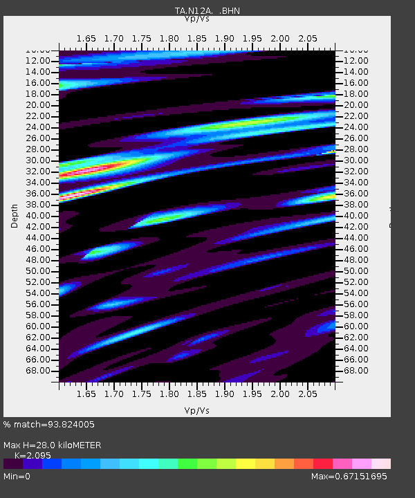
| Estimated Moho Depth: |
28.0 km |
| Estimated Crust Vp/Vs: |
2.10 |
| Assumed Crust Vp: |
6.276 km/s |
| Estimated Crust Vs: |
2.996 km/s |
| Estimated Crust Poisson's Ratio: |
0.35 |
|
| Radial Match: |
93.824005 % |
| Radial Bump: |
400 |
| Transverse Match: |
87.06723 % |
| Transverse Bump: |
400 |
| SOD ConfigId: |
2665 |
| Insert Time: |
2010-03-07 01:47:17.168 +0000 |
| GWidth: |
2.5 |
| Max Bumps: |
400 |
| Tol: |
0.001 |
|
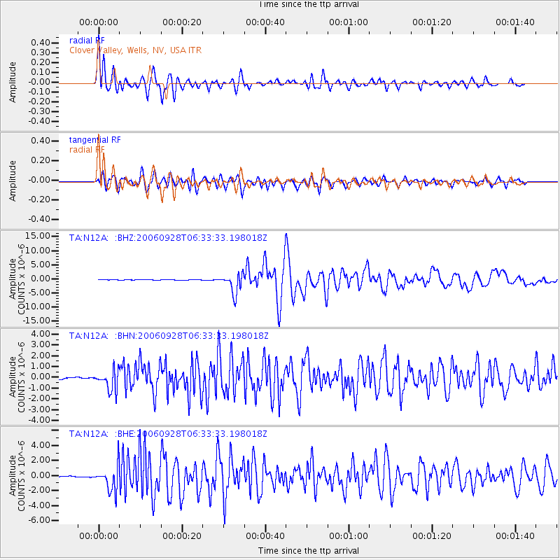
Signal To Noise
| Channel | StoN | STA | LTA |
| TA:N12A: :BHN:20060928T06:33:33.198018Z | 10.889205 | 9.4852385E-7 | 8.7106805E-8 |
| TA:N12A: :BHE:20060928T06:33:33.198018Z | 20.72441 | 1.7294582E-6 | 8.3450296E-8 |
| TA:N12A: :BHZ:20060928T06:33:33.198018Z | 55.53363 | 3.5817657E-6 | 6.4497236E-8 |
| Arrivals |
| Ps | 5.0 SECOND |
| PpPs | 13 SECOND |
| PsPs/PpSs | 18 SECOND |


