You are here: Home > Network List > TA - USArray Transportable Network (new EarthScope stations) Stations List
> Station N12A Clover Valley, Wells, NV, USA > Earthquake Result Viewer
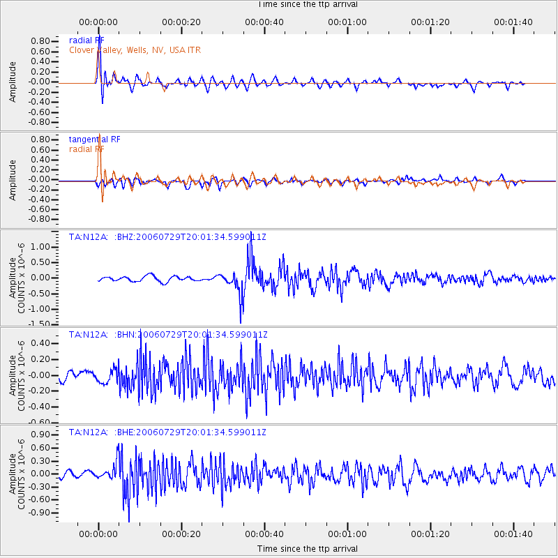
N12A Clover Valley, Wells, NV, USA - Earthquake Result Viewer
| Earthquake location: |
North Atlantic Ocean |
| Earthquake latitude/longitude: |
23.6/-63.9 |
| Earthquake time(UTC): |
2006/07/29 (210) 19:53:43 GMT |
| Earthquake Depth: |
10 km |
| Earthquake Magnitude: |
5.5 MB, 5.0 MS, 5.8 MW, 5.6 MW |
| Earthquake Catalog/Contributor: |
WHDF/NEIC |
|
| Network: |
TA USArray Transportable Network (new EarthScope stations) |
| Station: |
N12A Clover Valley, Wells, NV, USA |
| Lat/Lon: |
40.85 N/115.04 W |
| Elevation: |
1786 m |
|
| Distance: |
45.9 deg |
| Az: |
304.663 deg |
| Baz: |
95.869 deg |
| Ray Param: |
0.07098932 |
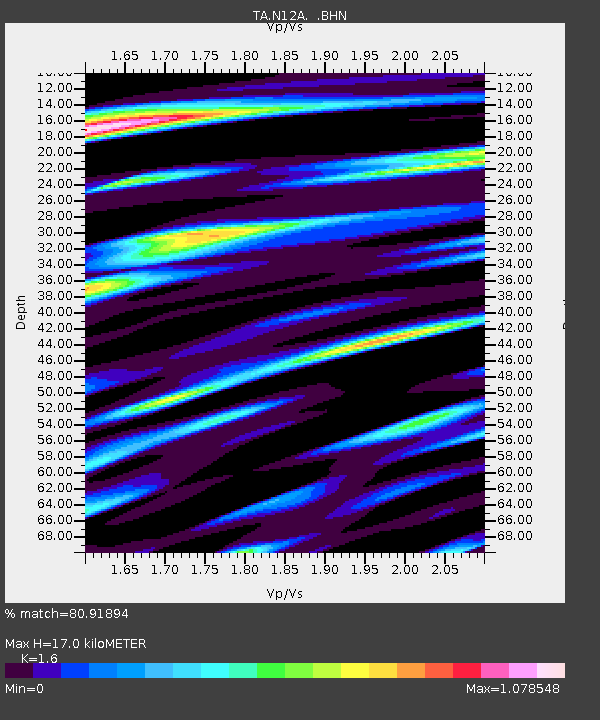
| Estimated Moho Depth: |
17.0 km |
| Estimated Crust Vp/Vs: |
1.60 |
| Assumed Crust Vp: |
6.276 km/s |
| Estimated Crust Vs: |
3.922 km/s |
| Estimated Crust Poisson's Ratio: |
0.18 |
|
| Radial Match: |
80.91894 % |
| Radial Bump: |
400 |
| Transverse Match: |
64.915405 % |
| Transverse Bump: |
400 |
| SOD ConfigId: |
2665 |
| Insert Time: |
2010-03-07 01:47:27.491 +0000 |
| GWidth: |
2.5 |
| Max Bumps: |
400 |
| Tol: |
0.001 |
|
Signal To Noise
| Channel | StoN | STA | LTA |
| TA:N12A: :BHN:20060729T20:01:34.599011Z | 1.3661417 | 8.5281684E-8 | 6.2425215E-8 |
| TA:N12A: :BHE:20060729T20:01:34.599011Z | 2.7826874 | 2.0619139E-7 | 7.409793E-8 |
| TA:N12A: :BHZ:20060729T20:01:34.599011Z | 4.4174232 | 3.6264422E-7 | 8.209406E-8 |
| Arrivals |
| Ps | 1.7 SECOND |
| PpPs | 6.6 SECOND |
| PsPs/PpSs | 8.3 SECOND |


