You are here: Home > Network List > TA - USArray Transportable Network (new EarthScope stations) Stations List
> Station N12A Clover Valley, Wells, NV, USA > Earthquake Result Viewer
N12A Clover Valley, Wells, NV, USA - Earthquake Result Viewer
| Earthquake location: |
Fiji Islands Region |
| Earthquake latitude/longitude: |
-19.9/-178.3 |
| Earthquake time(UTC): |
2006/06/27 (178) 02:59:15 GMT |
| Earthquake Depth: |
570 km |
| Earthquake Magnitude: |
6.0 MB, 6.2 MW |
| Earthquake Catalog/Contributor: |
WHDF/NEIC |
|
| Network: |
TA USArray Transportable Network (new EarthScope stations) |
| Station: |
N12A Clover Valley, Wells, NV, USA |
| Lat/Lon: |
40.85 N/115.04 W |
| Elevation: |
1786 m |
|
| Distance: |
84.2 deg |
| Az: |
42.912 deg |
| Baz: |
237.653 deg |
| Ray Param: |
0.043998722 |
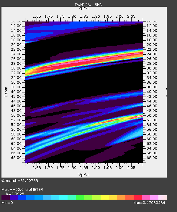
| Estimated Moho Depth: |
50.0 km |
| Estimated Crust Vp/Vs: |
2.09 |
| Assumed Crust Vp: |
6.276 km/s |
| Estimated Crust Vs: |
2.999 km/s |
| Estimated Crust Poisson's Ratio: |
0.35 |
|
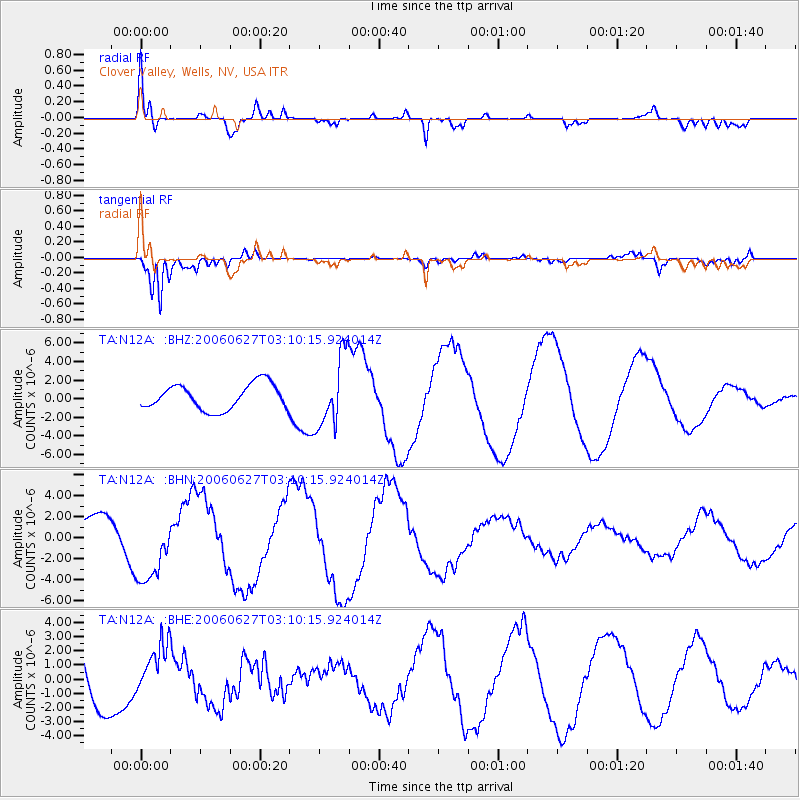
| Radial Match: |
81.20735 % |
| Radial Bump: |
400 |
| Transverse Match: |
94.35876 % |
| Transverse Bump: |
400 |
| SOD ConfigId: |
2665 |
| Insert Time: |
2010-03-07 01:47:33.050 +0000 |
| GWidth: |
2.5 |
| Max Bumps: |
400 |
| Tol: |
0.001 |
|
Signal To Noise
| Channel | StoN | STA | LTA |
| TA:N12A: :BHN:20060627T03:10:15.924014Z | 2.3120666 | 3.3989736E-6 | 1.470102E-6 |
| TA:N12A: :BHE:20060627T03:10:15.924014Z | 0.7738568 | 1.792643E-6 | 2.3165048E-6 |
| TA:N12A: :BHZ:20060627T03:10:15.924014Z | 2.783799 | 3.8069618E-6 | 1.3675419E-6 |
| Arrivals |
| Ps | 8.9 SECOND |
| PpPs | 24 SECOND |
| PsPs/PpSs | 33 SECOND |


