You are here: Home > Network List > TA - USArray Transportable Network (new EarthScope stations) Stations List
> Station S31K Pelican, AK, USA > Earthquake Result Viewer
S31K Pelican, AK, USA - Earthquake Result Viewer
| Earthquake location: |
Mariana Islands |
| Earthquake latitude/longitude: |
19.9/144.3 |
| Earthquake time(UTC): |
2019/06/28 (179) 15:51:31 GMT |
| Earthquake Depth: |
410 km |
| Earthquake Magnitude: |
6.4 Mww |
| Earthquake Catalog/Contributor: |
NEIC PDE/us |
|
| Network: |
TA USArray Transportable Network (new EarthScope stations) |
| Station: |
S31K Pelican, AK, USA |
| Lat/Lon: |
57.96 N/136.23 W |
| Elevation: |
34 m |
|
| Distance: |
67.8 deg |
| Az: |
34.466 deg |
| Baz: |
272.087 deg |
| Ray Param: |
0.055390347 |
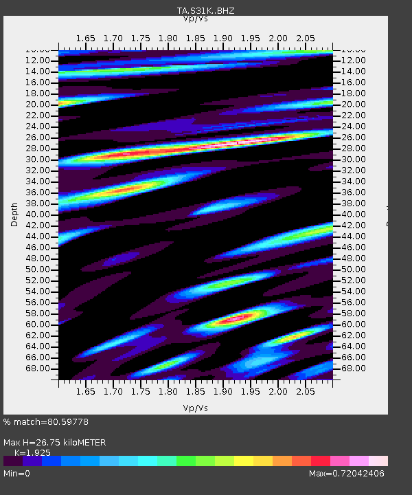
| Estimated Moho Depth: |
26.75 km |
| Estimated Crust Vp/Vs: |
1.92 |
| Assumed Crust Vp: |
6.134 km/s |
| Estimated Crust Vs: |
3.186 km/s |
| Estimated Crust Poisson's Ratio: |
0.32 |
|
| Radial Match: |
80.59778 % |
| Radial Bump: |
400 |
| Transverse Match: |
67.24481 % |
| Transverse Bump: |
400 |
| SOD ConfigId: |
19053131 |
| Insert Time: |
2019-07-27 14:07:06.267 +0000 |
| GWidth: |
2.5 |
| Max Bumps: |
400 |
| Tol: |
0.001 |
|

Signal To Noise
| Channel | StoN | STA | LTA |
| TA:S31K: :BHZ:20190628T16:01:15.82501Z | 9.877731 | 1.336492E-6 | 1.3530354E-7 |
| TA:S31K: :BHN:20190628T16:01:15.82501Z | 2.3722327 | 3.1868672E-7 | 1.3434043E-7 |
| TA:S31K: :BHE:20190628T16:01:15.82501Z | 5.7500076 | 6.500774E-7 | 1.13056785E-7 |
| Arrivals |
| Ps | 4.2 SECOND |
| PpPs | 12 SECOND |
| PsPs/PpSs | 17 SECOND |


