You are here: Home > Network List > US - United States National Seismic Network Stations List
> Station HAWA Hanford, Washington, USA > Earthquake Result Viewer
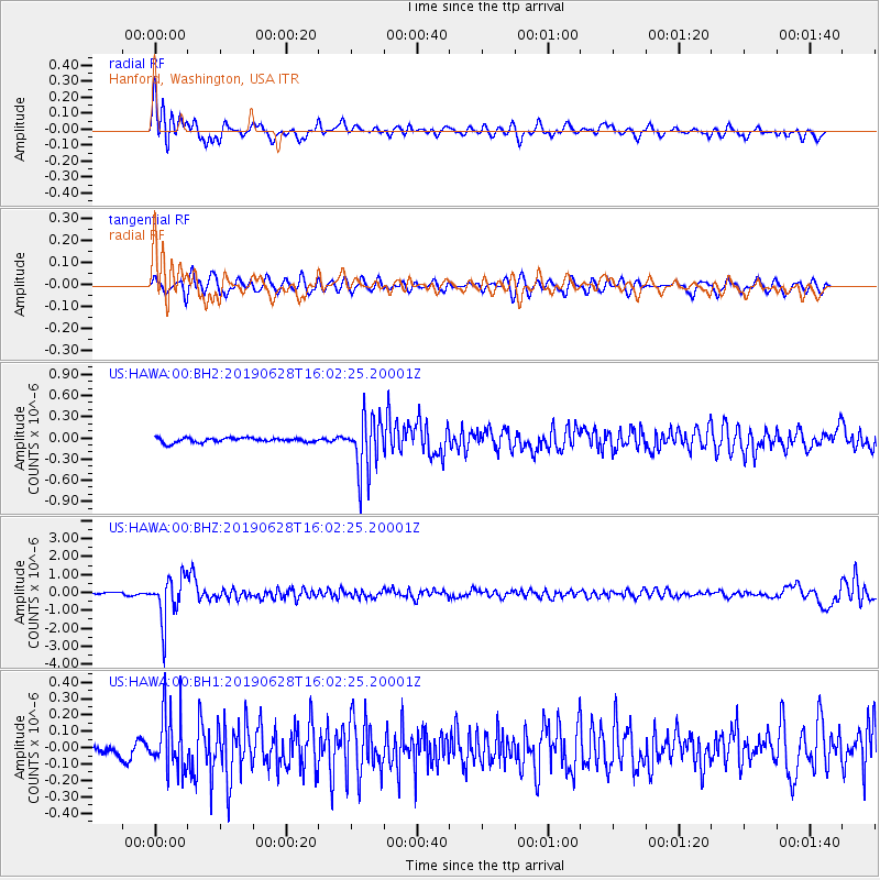
HAWA Hanford, Washington, USA - Earthquake Result Viewer
*The percent match for this event was below the threshold and hence no stack was calculated.
| Earthquake location: |
Mariana Islands |
| Earthquake latitude/longitude: |
19.9/144.3 |
| Earthquake time(UTC): |
2019/06/28 (179) 15:51:31 GMT |
| Earthquake Depth: |
410 km |
| Earthquake Magnitude: |
6.4 Mww |
| Earthquake Catalog/Contributor: |
NEIC PDE/us |
|
| Network: |
US United States National Seismic Network |
| Station: |
HAWA Hanford, Washington, USA |
| Lat/Lon: |
46.39 N/119.53 W |
| Elevation: |
364 m |
|
| Distance: |
80.0 deg |
| Az: |
44.337 deg |
| Baz: |
288.109 deg |
| Ray Param: |
$rayparam |
*The percent match for this event was below the threshold and hence was not used in the summary stack. |
|
| Radial Match: |
78.828026 % |
| Radial Bump: |
400 |
| Transverse Match: |
61.196735 % |
| Transverse Bump: |
400 |
| SOD ConfigId: |
19053131 |
| Insert Time: |
2019-07-27 14:07:45.943 +0000 |
| GWidth: |
2.5 |
| Max Bumps: |
400 |
| Tol: |
0.001 |
|
Signal To Noise
| Channel | StoN | STA | LTA |
| US:HAWA:00:BHZ:20190628T16:02:25.20001Z | 22.009035 | 1.2177899E-6 | 5.533136E-8 |
| US:HAWA:00:BH1:20190628T16:02:25.20001Z | 4.2648697 | 1.7728024E-7 | 4.1567564E-8 |
| US:HAWA:00:BH2:20190628T16:02:25.20001Z | 12.577948 | 3.9761258E-7 | 3.161188E-8 |
| Arrivals |
| Ps | |
| PpPs | |
| PsPs/PpSs | |


