You are here: Home > Network List > TA - USArray Transportable Network (new EarthScope stations) Stations List
> Station O11A Cowboy Ranch, Jiggs, NV, USA > Earthquake Result Viewer
O11A Cowboy Ranch, Jiggs, NV, USA - Earthquake Result Viewer
| Earthquake location: |
South Of Fiji Islands |
| Earthquake latitude/longitude: |
-25.8/179.5 |
| Earthquake time(UTC): |
2007/10/16 (289) 21:05:43 GMT |
| Earthquake Depth: |
509 km |
| Earthquake Magnitude: |
6.2 MB, 6.6 MW, 6.5 MW |
| Earthquake Catalog/Contributor: |
WHDF/NEIC |
|
| Network: |
TA USArray Transportable Network (new EarthScope stations) |
| Station: |
O11A Cowboy Ranch, Jiggs, NV, USA |
| Lat/Lon: |
40.13 N/115.66 W |
| Elevation: |
1948 m |
|
| Distance: |
89.1 deg |
| Az: |
43.939 deg |
| Baz: |
234.69 deg |
| Ray Param: |
0.04163808 |
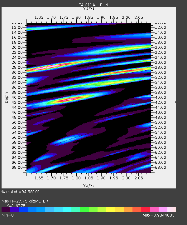
| Estimated Moho Depth: |
27.75 km |
| Estimated Crust Vp/Vs: |
1.68 |
| Assumed Crust Vp: |
6.276 km/s |
| Estimated Crust Vs: |
3.741 km/s |
| Estimated Crust Poisson's Ratio: |
0.22 |
|
| Radial Match: |
94.98101 % |
| Radial Bump: |
300 |
| Transverse Match: |
90.85573 % |
| Transverse Bump: |
400 |
| SOD ConfigId: |
2564 |
| Insert Time: |
2010-03-07 01:48:12.249 +0000 |
| GWidth: |
2.5 |
| Max Bumps: |
400 |
| Tol: |
0.001 |
|
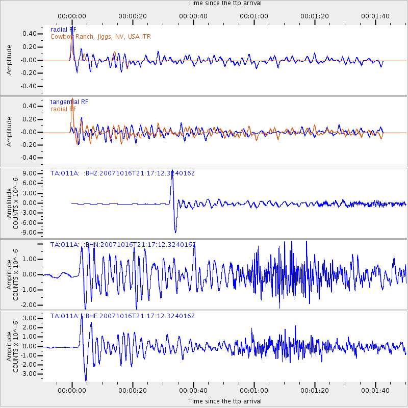
Signal To Noise
| Channel | StoN | STA | LTA |
| TA:O11A: :BHN:20071016T21:17:12.324016Z | 16.335514 | 9.3507606E-7 | 5.7241913E-8 |
| TA:O11A: :BHE:20071016T21:17:12.324016Z | 26.092886 | 1.6289845E-6 | 6.243022E-8 |
| TA:O11A: :BHZ:20071016T21:17:12.324016Z | 65.25709 | 4.372622E-6 | 6.7006084E-8 |
| Arrivals |
| Ps | 3.1 SECOND |
| PpPs | 12 SECOND |
| PsPs/PpSs | 15 SECOND |


