You are here: Home > Network List > TA - USArray Transportable Network (new EarthScope stations) Stations List
> Station O11A Cowboy Ranch, Jiggs, NV, USA > Earthquake Result Viewer
O11A Cowboy Ranch, Jiggs, NV, USA - Earthquake Result Viewer
| Earthquake location: |
Jujuy Province, Argentina |
| Earthquake latitude/longitude: |
-22.2/-65.8 |
| Earthquake time(UTC): |
2007/07/21 (202) 15:34:52 GMT |
| Earthquake Depth: |
290 km |
| Earthquake Magnitude: |
5.8 MB, 6.4 MW, 6.3 MW |
| Earthquake Catalog/Contributor: |
WHDF/NEIC |
|
| Network: |
TA USArray Transportable Network (new EarthScope stations) |
| Station: |
O11A Cowboy Ranch, Jiggs, NV, USA |
| Lat/Lon: |
40.13 N/115.66 W |
| Elevation: |
1948 m |
|
| Distance: |
77.4 deg |
| Az: |
323.084 deg |
| Baz: |
133.424 deg |
| Ray Param: |
0.04953042 |
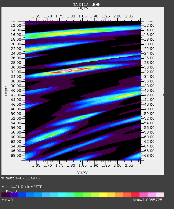
| Estimated Moho Depth: |
31.0 km |
| Estimated Crust Vp/Vs: |
1.80 |
| Assumed Crust Vp: |
6.276 km/s |
| Estimated Crust Vs: |
3.487 km/s |
| Estimated Crust Poisson's Ratio: |
0.28 |
|
| Radial Match: |
87.114975 % |
| Radial Bump: |
400 |
| Transverse Match: |
75.75111 % |
| Transverse Bump: |
400 |
| SOD ConfigId: |
2564 |
| Insert Time: |
2010-03-07 01:48:49.054 +0000 |
| GWidth: |
2.5 |
| Max Bumps: |
400 |
| Tol: |
0.001 |
|
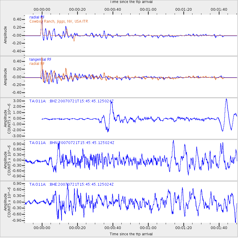
Signal To Noise
| Channel | StoN | STA | LTA |
| TA:O11A: :BHN:20070721T15:45:45.125024Z | 1.5764618 | 1.2151777E-7 | 7.708259E-8 |
| TA:O11A: :BHE:20070721T15:45:45.125024Z | 0.92704076 | 6.974995E-8 | 7.5239356E-8 |
| TA:O11A: :BHZ:20070721T15:45:45.125024Z | 5.3336973 | 2.9287725E-7 | 5.4910736E-8 |
| Arrivals |
| Ps | 4.1 SECOND |
| PpPs | 13 SECOND |
| PsPs/PpSs | 18 SECOND |


