You are here: Home > Network List > TA - USArray Transportable Network (new EarthScope stations) Stations List
> Station O11A Cowboy Ranch, Jiggs, NV, USA > Earthquake Result Viewer
O11A Cowboy Ranch, Jiggs, NV, USA - Earthquake Result Viewer
| Earthquake location: |
Near Coast Of Guatemala |
| Earthquake latitude/longitude: |
14.0/-91.2 |
| Earthquake time(UTC): |
2006/12/03 (337) 20:52:15 GMT |
| Earthquake Depth: |
61 km |
| Earthquake Magnitude: |
5.8 MB, 5.9 MW, 5.9 MW |
| Earthquake Catalog/Contributor: |
WHDF/NEIC |
|
| Network: |
TA USArray Transportable Network (new EarthScope stations) |
| Station: |
O11A Cowboy Ranch, Jiggs, NV, USA |
| Lat/Lon: |
40.13 N/115.66 W |
| Elevation: |
1948 m |
|
| Distance: |
33.7 deg |
| Az: |
325.135 deg |
| Baz: |
133.636 deg |
| Ray Param: |
0.07793089 |
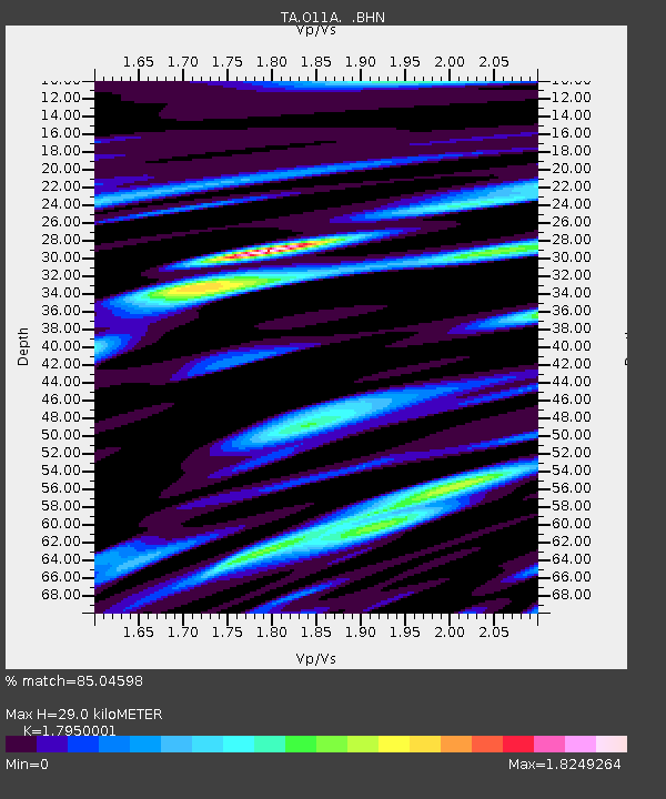
| Estimated Moho Depth: |
29.0 km |
| Estimated Crust Vp/Vs: |
1.80 |
| Assumed Crust Vp: |
6.276 km/s |
| Estimated Crust Vs: |
3.496 km/s |
| Estimated Crust Poisson's Ratio: |
0.27 |
|
| Radial Match: |
85.04598 % |
| Radial Bump: |
400 |
| Transverse Match: |
77.97282 % |
| Transverse Bump: |
400 |
| SOD ConfigId: |
2564 |
| Insert Time: |
2010-03-07 01:49:38.443 +0000 |
| GWidth: |
2.5 |
| Max Bumps: |
400 |
| Tol: |
0.001 |
|
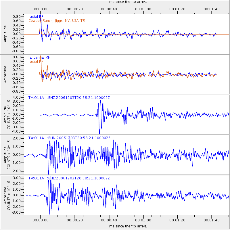
Signal To Noise
| Channel | StoN | STA | LTA |
| TA:O11A: :BHN:20061203T20:58:21.100002Z | 5.852403 | 7.129692E-7 | 1.2182504E-7 |
| TA:O11A: :BHE:20061203T20:58:21.100002Z | 9.518015 | 8.237968E-7 | 8.6551324E-8 |
| TA:O11A: :BHZ:20061203T20:58:21.100002Z | 10.616898 | 1.3822364E-6 | 1.3019212E-7 |
| Arrivals |
| Ps | 4.0 SECOND |
| PpPs | 12 SECOND |
| PsPs/PpSs | 16 SECOND |


