You are here: Home > Network List > AV - Alaska Volcano Observatory Stations List
> Station SPU Mount Spurr, Mount Spurr, Alaska > Earthquake Result Viewer
SPU Mount Spurr, Mount Spurr, Alaska - Earthquake Result Viewer
| Earthquake location: |
Halmahera, Indonesia |
| Earthquake latitude/longitude: |
-0.5/128.1 |
| Earthquake time(UTC): |
2019/07/14 (195) 09:10:50 GMT |
| Earthquake Depth: |
10 km |
| Earthquake Magnitude: |
7.3 Mww |
| Earthquake Catalog/Contributor: |
NEIC PDE/us |
|
| Network: |
AV Alaska Volcano Observatory |
| Station: |
SPU Mount Spurr, Mount Spurr, Alaska |
| Lat/Lon: |
61.18 N/152.06 W |
| Elevation: |
800 m |
|
| Distance: |
85.6 deg |
| Az: |
28.58 deg |
| Baz: |
260.847 deg |
| Ray Param: |
0.044674467 |
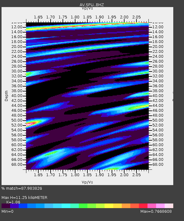
| Estimated Moho Depth: |
11.25 km |
| Estimated Crust Vp/Vs: |
1.86 |
| Assumed Crust Vp: |
6.566 km/s |
| Estimated Crust Vs: |
3.53 km/s |
| Estimated Crust Poisson's Ratio: |
0.30 |
|
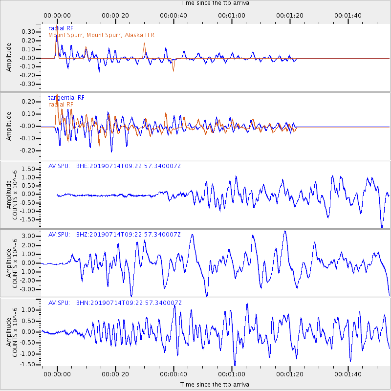
| Radial Match: |
87.983826 % |
| Radial Bump: |
400 |
| Transverse Match: |
81.97616 % |
| Transverse Bump: |
400 |
| SOD ConfigId: |
19053131 |
| Insert Time: |
2019-07-28 09:12:26.568 +0000 |
| GWidth: |
2.5 |
| Max Bumps: |
400 |
| Tol: |
0.001 |
|
Signal To Noise
| Channel | StoN | STA | LTA |
| AV:SPU: :BHZ:20190714T09:22:57.340007Z | 4.415044 | 1.7505485E-7 | 3.9649628E-8 |
| AV:SPU: :BHN:20190714T09:22:57.340007Z | 1.3286203 | 4.8562004E-8 | 3.65507E-8 |
| AV:SPU: :BHE:20190714T09:22:57.340007Z | 1.109243 | 4.057774E-8 | 3.6581465E-8 |
| Arrivals |
| Ps | 1.5 SECOND |
| PpPs | 4.8 SECOND |
| PsPs/PpSs | 6.3 SECOND |


