You are here: Home > Network List > G - GEOSCOPE Stations List
> Station INU Inuyama, Japan > Earthquake Result Viewer
INU Inuyama, Japan - Earthquake Result Viewer
| Earthquake location: |
Halmahera, Indonesia |
| Earthquake latitude/longitude: |
-0.5/128.1 |
| Earthquake time(UTC): |
2019/07/14 (195) 09:10:50 GMT |
| Earthquake Depth: |
10 km |
| Earthquake Magnitude: |
7.3 Mww |
| Earthquake Catalog/Contributor: |
NEIC PDE/us |
|
| Network: |
G GEOSCOPE |
| Station: |
INU Inuyama, Japan |
| Lat/Lon: |
35.35 N/137.03 E |
| Elevation: |
132 m |
|
| Distance: |
36.7 deg |
| Az: |
12.28 deg |
| Baz: |
195.08 deg |
| Ray Param: |
0.07656127 |
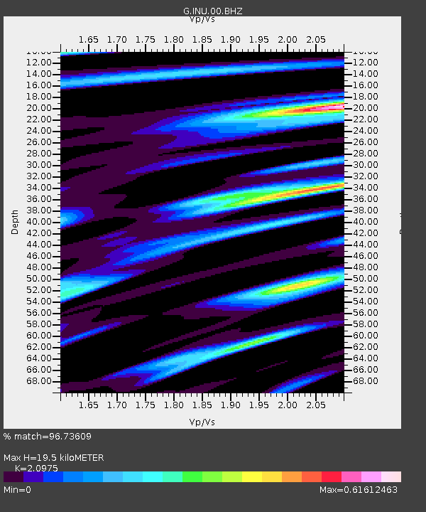
| Estimated Moho Depth: |
19.5 km |
| Estimated Crust Vp/Vs: |
2.10 |
| Assumed Crust Vp: |
6.461 km/s |
| Estimated Crust Vs: |
3.081 km/s |
| Estimated Crust Poisson's Ratio: |
0.35 |
|
| Radial Match: |
96.73609 % |
| Radial Bump: |
329 |
| Transverse Match: |
80.51896 % |
| Transverse Bump: |
400 |
| SOD ConfigId: |
19053131 |
| Insert Time: |
2019-07-28 09:12:45.160 +0000 |
| GWidth: |
2.5 |
| Max Bumps: |
400 |
| Tol: |
0.001 |
|

Signal To Noise
| Channel | StoN | STA | LTA |
| G:INU:00:BHZ:20190714T09:17:26.410991Z | 12.268214 | 2.3427585E-6 | 1.9096166E-7 |
| G:INU:00:BHN:20190714T09:17:26.410991Z | 4.4245167 | 8.3656545E-7 | 1.89075E-7 |
| G:INU:00:BHE:20190714T09:17:26.410991Z | 4.3626184 | 6.523377E-7 | 1.4952893E-7 |
| Arrivals |
| Ps | 3.5 SECOND |
| PpPs | 8.8 SECOND |
| PsPs/PpSs | 12 SECOND |


