You are here: Home > Network List > TA - USArray Transportable Network (new EarthScope stations) Stations List
> Station O11A Cowboy Ranch, Jiggs, NV, USA > Earthquake Result Viewer
O11A Cowboy Ranch, Jiggs, NV, USA - Earthquake Result Viewer
| Earthquake location: |
Kuril Islands |
| Earthquake latitude/longitude: |
46.3/153.3 |
| Earthquake time(UTC): |
2006/10/13 (286) 13:47:39 GMT |
| Earthquake Depth: |
8.0 km |
| Earthquake Magnitude: |
5.5 MB, 5.8 MS, 6.3 MW, 5.8 MW |
| Earthquake Catalog/Contributor: |
WHDF/NEIC |
|
| Network: |
TA USArray Transportable Network (new EarthScope stations) |
| Station: |
O11A Cowboy Ranch, Jiggs, NV, USA |
| Lat/Lon: |
40.13 N/115.66 W |
| Elevation: |
1948 m |
|
| Distance: |
63.1 deg |
| Az: |
59.267 deg |
| Baz: |
308.926 deg |
| Ray Param: |
0.05979907 |
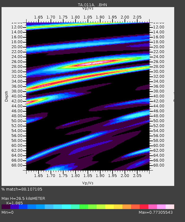
| Estimated Moho Depth: |
26.5 km |
| Estimated Crust Vp/Vs: |
1.87 |
| Assumed Crust Vp: |
6.276 km/s |
| Estimated Crust Vs: |
3.365 km/s |
| Estimated Crust Poisson's Ratio: |
0.30 |
|
| Radial Match: |
88.107185 % |
| Radial Bump: |
377 |
| Transverse Match: |
71.77738 % |
| Transverse Bump: |
400 |
| SOD ConfigId: |
2665 |
| Insert Time: |
2010-03-07 01:49:54.614 +0000 |
| GWidth: |
2.5 |
| Max Bumps: |
400 |
| Tol: |
0.001 |
|
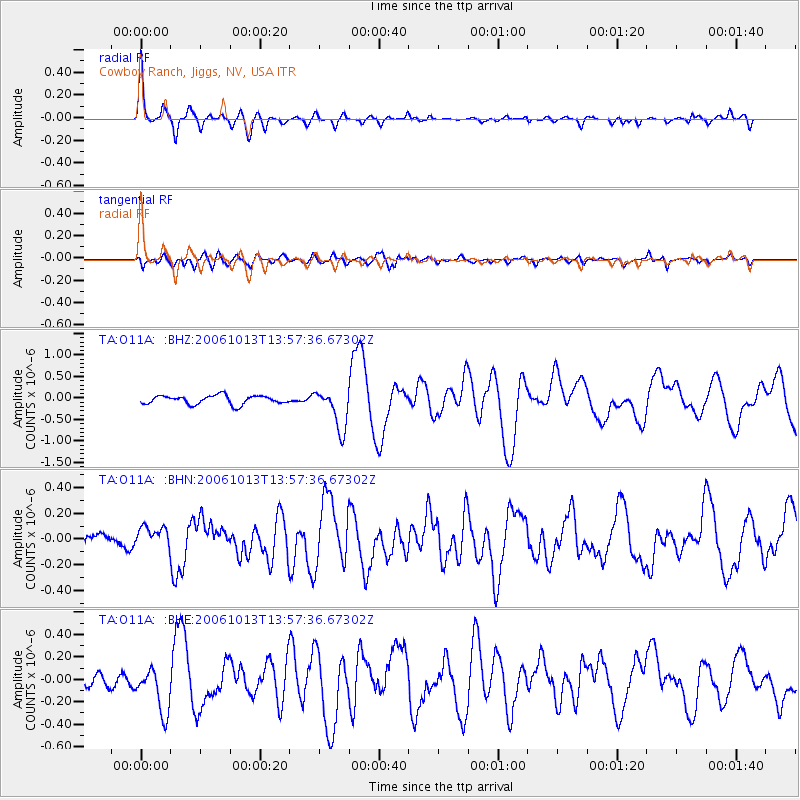
Signal To Noise
| Channel | StoN | STA | LTA |
| TA:O11A: :BHN:20061013T13:57:36.67302Z | 1.0771775 | 8.505862E-8 | 7.896434E-8 |
| TA:O11A: :BHE:20061013T13:57:36.67302Z | 2.8775897 | 2.0715476E-7 | 7.1988985E-8 |
| TA:O11A: :BHZ:20061013T13:57:36.67302Z | 4.674674 | 4.7457524E-7 | 1.015205E-7 |
| Arrivals |
| Ps | 3.8 SECOND |
| PpPs | 12 SECOND |
| PsPs/PpSs | 15 SECOND |


