You are here: Home > Network List > TA - USArray Transportable Network (new EarthScope stations) Stations List
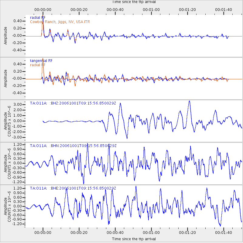
> Station O11A Cowboy Ranch, Jiggs, NV, USA > Earthquake Result Viewer
O11A Cowboy Ranch, Jiggs, NV, USA - Earthquake Result Viewer
| Earthquake location: |
Kuril Islands |
| Earthquake latitude/longitude: |
46.5/153.2 |
| Earthquake time(UTC): |
2006/10/01 (274) 09:06:02 GMT |
| Earthquake Depth: |
19 km |
| Earthquake Magnitude: |
6.1 MB, 6.4 MS, 6.6 MW, 6.5 MW |
| Earthquake Catalog/Contributor: |
WHDF/NEIC |
|
| Network: |
TA USArray Transportable Network (new EarthScope stations) |
| Station: |
O11A Cowboy Ranch, Jiggs, NV, USA |
| Lat/Lon: |
40.13 N/115.66 W |
| Elevation: |
1948 m |
|
| Distance: |
63.0 deg |
| Az: |
59.341 deg |
| Baz: |
309.152 deg |
| Ray Param: |
0.059832305 |
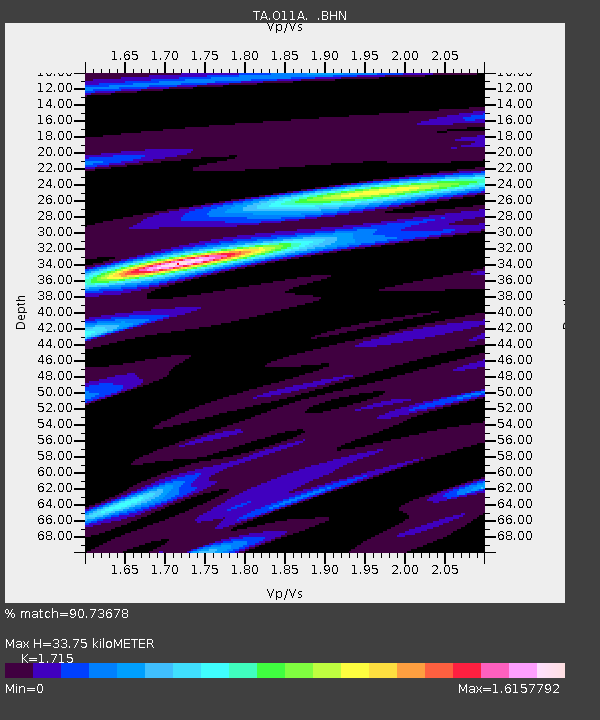
| Estimated Moho Depth: |
33.75 km |
| Estimated Crust Vp/Vs: |
1.72 |
| Assumed Crust Vp: |
6.276 km/s |
| Estimated Crust Vs: |
3.659 km/s |
| Estimated Crust Poisson's Ratio: |
0.24 |
|
| Radial Match: |
90.73678 % |
| Radial Bump: |
400 |
| Transverse Match: |
79.775986 % |
| Transverse Bump: |
400 |
| SOD ConfigId: |
2665 |
| Insert Time: |
2010-03-07 01:50:02.578 +0000 |
| GWidth: |
2.5 |
| Max Bumps: |
400 |
| Tol: |
0.001 |
|
Signal To Noise
| Channel | StoN | STA | LTA |
| TA:O11A: :BHN:20061001T09:15:56.850029Z | 2.503877 | 2.0906006E-7 | 8.349454E-8 |
| TA:O11A: :BHE:20061001T09:15:56.850029Z | 1.4479653 | 2.026023E-7 | 1.3992207E-7 |
| TA:O11A: :BHZ:20061001T09:15:56.850029Z | 6.750752 | 4.93954E-7 | 7.317023E-8 |
| Arrivals |
| Ps | 4.0 SECOND |
| PpPs | 14 SECOND |
| PsPs/PpSs | 18 SECOND |


