You are here: Home > Network List > MM - Myanmar National Seismic Network Stations List
> Station SIM Sittwe, Rakhine, Myanmar > Earthquake Result Viewer
SIM Sittwe, Rakhine, Myanmar - Earthquake Result Viewer
| Earthquake location: |
Halmahera, Indonesia |
| Earthquake latitude/longitude: |
-0.5/128.1 |
| Earthquake time(UTC): |
2019/07/14 (195) 09:10:50 GMT |
| Earthquake Depth: |
10 km |
| Earthquake Magnitude: |
7.3 Mww |
| Earthquake Catalog/Contributor: |
NEIC PDE/us |
|
| Network: |
MM Myanmar National Seismic Network |
| Station: |
SIM Sittwe, Rakhine, Myanmar |
| Lat/Lon: |
20.13 N/92.89 E |
| Elevation: |
15 m |
|
| Distance: |
40.1 deg |
| Az: |
302.805 deg |
| Baz: |
116.559 deg |
| Ray Param: |
0.074569084 |
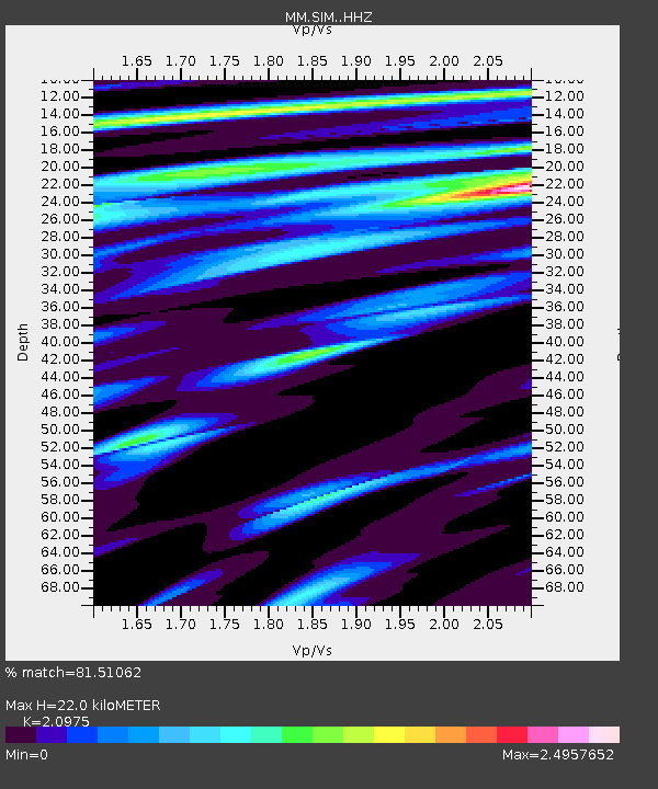
| Estimated Moho Depth: |
22.0 km |
| Estimated Crust Vp/Vs: |
2.10 |
| Assumed Crust Vp: |
6.444 km/s |
| Estimated Crust Vs: |
3.072 km/s |
| Estimated Crust Poisson's Ratio: |
0.35 |
|
| Radial Match: |
81.51062 % |
| Radial Bump: |
400 |
| Transverse Match: |
80.283646 % |
| Transverse Bump: |
400 |
| SOD ConfigId: |
19053131 |
| Insert Time: |
2019-07-28 09:13:37.905 +0000 |
| GWidth: |
2.5 |
| Max Bumps: |
400 |
| Tol: |
0.001 |
|

Signal To Noise
| Channel | StoN | STA | LTA |
| MM:SIM: :HHZ:20190714T09:17:55.578013Z | 2.7369907 | 2.2300208E-6 | 8.14771E-7 |
| MM:SIM: :HHN:20190714T09:17:55.578013Z | 0.9830494 | 1.1779147E-6 | 1.1982253E-6 |
| MM:SIM: :HHE:20190714T09:17:55.578013Z | 1.3377535 | 1.9825352E-6 | 1.4819884E-6 |
| Arrivals |
| Ps | 4.0 SECOND |
| PpPs | 10.0 SECOND |
| PsPs/PpSs | 14 SECOND |


