You are here: Home > Network List > TA - USArray Transportable Network (new EarthScope stations) Stations List
> Station F21K Alatna River, AK, USA > Earthquake Result Viewer
F21K Alatna River, AK, USA - Earthquake Result Viewer
| Earthquake location: |
Halmahera, Indonesia |
| Earthquake latitude/longitude: |
-0.5/128.1 |
| Earthquake time(UTC): |
2019/07/14 (195) 09:10:50 GMT |
| Earthquake Depth: |
10 km |
| Earthquake Magnitude: |
7.3 Mww |
| Earthquake Catalog/Contributor: |
NEIC PDE/us |
|
| Network: |
TA USArray Transportable Network (new EarthScope stations) |
| Station: |
F21K Alatna River, AK, USA |
| Lat/Lon: |
67.22 N/153.48 W |
| Elevation: |
597 m |
|
| Distance: |
86.0 deg |
| Az: |
22.481 deg |
| Baz: |
259.114 deg |
| Ray Param: |
0.044359863 |
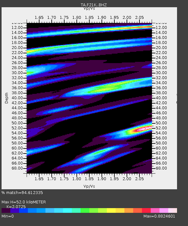
| Estimated Moho Depth: |
52.0 km |
| Estimated Crust Vp/Vs: |
2.07 |
| Assumed Crust Vp: |
6.455 km/s |
| Estimated Crust Vs: |
3.115 km/s |
| Estimated Crust Poisson's Ratio: |
0.35 |
|
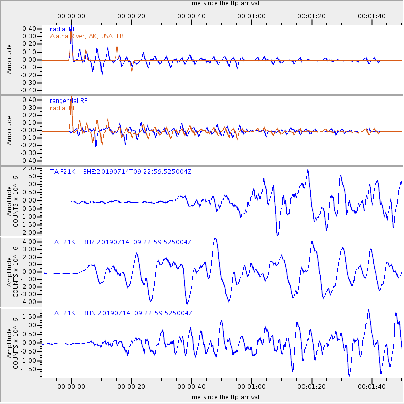
| Radial Match: |
94.612335 % |
| Radial Bump: |
400 |
| Transverse Match: |
88.53752 % |
| Transverse Bump: |
400 |
| SOD ConfigId: |
19053131 |
| Insert Time: |
2019-07-28 09:14:23.812 +0000 |
| GWidth: |
2.5 |
| Max Bumps: |
400 |
| Tol: |
0.001 |
|
Signal To Noise
| Channel | StoN | STA | LTA |
| TA:F21K: :BHZ:20190714T09:22:59.525004Z | 5.986327 | 1.8501957E-7 | 3.0907028E-8 |
| TA:F21K: :BHN:20190714T09:22:59.525004Z | 0.88884485 | 3.9130303E-8 | 4.402377E-8 |
| TA:F21K: :BHE:20190714T09:22:59.525004Z | 1.5593895 | 5.9063066E-8 | 3.7875765E-8 |
| Arrivals |
| Ps | 8.8 SECOND |
| PpPs | 24 SECOND |
| PsPs/PpSs | 33 SECOND |


