You are here: Home > Network List > TA - USArray Transportable Network (new EarthScope stations) Stations List
> Station H31M Peel River, Yukon, CAN > Earthquake Result Viewer
H31M Peel River, Yukon, CAN - Earthquake Result Viewer
| Earthquake location: |
Halmahera, Indonesia |
| Earthquake latitude/longitude: |
-0.5/128.1 |
| Earthquake time(UTC): |
2019/07/14 (195) 09:10:50 GMT |
| Earthquake Depth: |
10 km |
| Earthquake Magnitude: |
7.3 Mww |
| Earthquake Catalog/Contributor: |
NEIC PDE/us |
|
| Network: |
TA USArray Transportable Network (new EarthScope stations) |
| Station: |
H31M Peel River, Yukon, CAN |
| Lat/Lon: |
65.81 N/134.34 W |
| Elevation: |
642 m |
|
| Distance: |
93.6 deg |
| Az: |
24.164 deg |
| Baz: |
276.683 deg |
| Ray Param: |
0.04123078 |
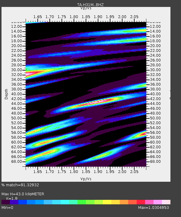
| Estimated Moho Depth: |
43.0 km |
| Estimated Crust Vp/Vs: |
1.90 |
| Assumed Crust Vp: |
6.419 km/s |
| Estimated Crust Vs: |
3.379 km/s |
| Estimated Crust Poisson's Ratio: |
0.31 |
|
| Radial Match: |
91.32932 % |
| Radial Bump: |
400 |
| Transverse Match: |
86.7667 % |
| Transverse Bump: |
400 |
| SOD ConfigId: |
19053131 |
| Insert Time: |
2019-07-28 09:14:37.356 +0000 |
| GWidth: |
2.5 |
| Max Bumps: |
400 |
| Tol: |
0.001 |
|
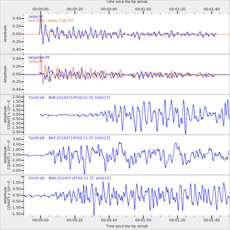
Signal To Noise
| Channel | StoN | STA | LTA |
| TA:H31M: :BHZ:20190714T09:23:35.100017Z | 2.2443657 | 1.6825577E-7 | 7.496808E-8 |
| TA:H31M: :BHN:20190714T09:23:35.100017Z | 1.020913 | 5.286691E-8 | 5.178395E-8 |
| TA:H31M: :BHE:20190714T09:23:35.100017Z | 1.4714425 | 8.626739E-8 | 5.862777E-8 |
| Arrivals |
| Ps | 6.1 SECOND |
| PpPs | 19 SECOND |
| PsPs/PpSs | 25 SECOND |


