You are here: Home > Network List > TA - USArray Transportable Network (new EarthScope stations) Stations List
> Station J25K Salcha River, AK, USA > Earthquake Result Viewer
J25K Salcha River, AK, USA - Earthquake Result Viewer

| Earthquake location: |
Halmahera, Indonesia |
| Earthquake latitude/longitude: |
-0.5/128.1 |
| Earthquake time(UTC): |
2019/07/14 (195) 09:10:50 GMT |
| Earthquake Depth: |
10 km |
| Earthquake Magnitude: |
7.3 Mww |
| Earthquake Catalog/Contributor: |
NEIC PDE/us |
|
| Network: |
TA USArray Transportable Network (new EarthScope stations) |
| Station: |
J25K Salcha River, AK, USA |
| Lat/Lon: |
64.61 N/145.37 W |
| Elevation: |
949 m |
|
| Distance: |
89.0 deg |
| Az: |
25.491 deg |
| Baz: |
266.649 deg |
| Ray Param: |
0.042182323 |
| Estimated Moho Depth: |
35.25 km |
| Estimated Crust Vp/Vs: |
2.10 |
| Assumed Crust Vp: |
6.566 km/s |
| Estimated Crust Vs: |
3.13 km/s |
| Estimated Crust Poisson's Ratio: |
0.35 |
|
| Radial Match: |
92.630974 % |
| Radial Bump: |
373 |
| Transverse Match: |
81.06382 % |
| Transverse Bump: |
400 |
| SOD ConfigId: |
19053131 |
| Insert Time: |
2019-07-28 09:14:42.517 +0000 |
| GWidth: |
2.5 |
| Max Bumps: |
400 |
| Tol: |
0.001 |
|
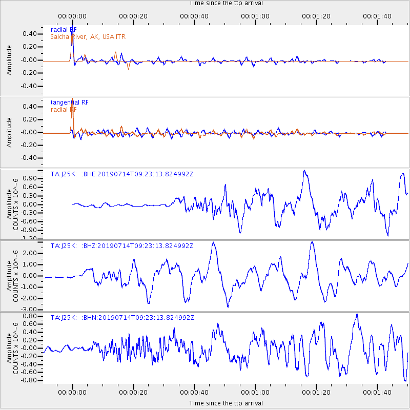
Signal To Noise
| Channel | StoN | STA | LTA |
| TA:J25K: :BHZ:20190714T09:23:13.824992Z | 3.9521766 | 2.7356518E-7 | 6.921886E-8 |
| TA:J25K: :BHN:20190714T09:23:13.824992Z | 0.6231916 | 2.7145683E-8 | 4.355913E-8 |
| TA:J25K: :BHE:20190714T09:23:13.824992Z | 2.9847126 | 1.1932022E-7 | 3.9977124E-8 |
| Arrivals |
| Ps | 6.0 SECOND |
| PpPs | 16 SECOND |
| PsPs/PpSs | 22 SECOND |


