You are here: Home > Network List > TA - USArray Transportable Network (new EarthScope stations) Stations List
> Station N11A Elko Archery Club, Elko, NV, USA > Earthquake Result Viewer
N11A Elko Archery Club, Elko, NV, USA - Earthquake Result Viewer
| Earthquake location: |
Volcano Islands, Japan Region |
| Earthquake latitude/longitude: |
22.0/142.7 |
| Earthquake time(UTC): |
2007/09/28 (271) 13:38:59 GMT |
| Earthquake Depth: |
276 km |
| Earthquake Magnitude: |
6.7 MB, 7.4 MW, 7.4 MW |
| Earthquake Catalog/Contributor: |
WHDF/NEIC |
|
| Network: |
TA USArray Transportable Network (new EarthScope stations) |
| Station: |
N11A Elko Archery Club, Elko, NV, USA |
| Lat/Lon: |
40.82 N/115.74 W |
| Elevation: |
1643 m |
|
| Distance: |
84.2 deg |
| Az: |
48.352 deg |
| Baz: |
293.981 deg |
| Ray Param: |
0.0449425 |
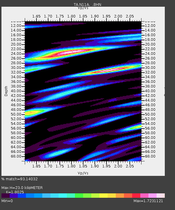
| Estimated Moho Depth: |
23.0 km |
| Estimated Crust Vp/Vs: |
1.80 |
| Assumed Crust Vp: |
6.276 km/s |
| Estimated Crust Vs: |
3.482 km/s |
| Estimated Crust Poisson's Ratio: |
0.28 |
|
| Radial Match: |
93.14032 % |
| Radial Bump: |
400 |
| Transverse Match: |
82.02941 % |
| Transverse Bump: |
400 |
| SOD ConfigId: |
2564 |
| Insert Time: |
2010-03-07 01:50:49.669 +0000 |
| GWidth: |
2.5 |
| Max Bumps: |
400 |
| Tol: |
0.001 |
|

Signal To Noise
| Channel | StoN | STA | LTA |
| TA:N11A: :BHN:20070928T13:50:28.925Z | 15.362795 | 2.330966E-6 | 1.5172799E-7 |
| TA:N11A: :BHE:20070928T13:50:28.925Z | 39.323856 | 5.4919E-6 | 1.3965823E-7 |
| TA:N11A: :BHZ:20070928T13:50:28.925Z | 88.16097 | 1.3218297E-5 | 1.4993365E-7 |
| Arrivals |
| Ps | 3.0 SECOND |
| PpPs | 10 SECOND |
| PsPs/PpSs | 13 SECOND |


