You are here: Home > Network List > TA - USArray Transportable Network (new EarthScope stations) Stations List
> Station J19K Poorman, AK, USA > Earthquake Result Viewer
J19K Poorman, AK, USA - Earthquake Result Viewer
| Earthquake location: |
Halmahera, Indonesia |
| Earthquake latitude/longitude: |
-0.8/127.8 |
| Earthquake time(UTC): |
2019/07/14 (195) 09:43:46 GMT |
| Earthquake Depth: |
10 km |
| Earthquake Magnitude: |
5.8 Mww |
| Earthquake Catalog/Contributor: |
NEIC PDE/us |
|
| Network: |
TA USArray Transportable Network (new EarthScope stations) |
| Station: |
J19K Poorman, AK, USA |
| Lat/Lon: |
63.99 N/155.62 W |
| Elevation: |
389 m |
|
| Distance: |
84.8 deg |
| Az: |
25.508 deg |
| Baz: |
257.616 deg |
| Ray Param: |
0.04518854 |
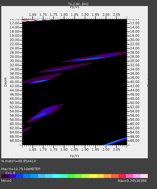
| Estimated Moho Depth: |
10.75 km |
| Estimated Crust Vp/Vs: |
1.60 |
| Assumed Crust Vp: |
6.438 km/s |
| Estimated Crust Vs: |
4.024 km/s |
| Estimated Crust Poisson's Ratio: |
0.18 |
|
| Radial Match: |
88.954414 % |
| Radial Bump: |
400 |
| Transverse Match: |
62.128525 % |
| Transverse Bump: |
376 |
| SOD ConfigId: |
19053131 |
| Insert Time: |
2019-07-28 09:46:28.655 +0000 |
| GWidth: |
2.5 |
| Max Bumps: |
400 |
| Tol: |
0.001 |
|

Signal To Noise
| Channel | StoN | STA | LTA |
| TA:J19K: :BHZ:20190714T09:55:49.275023Z | 0.82898456 | 9.507872E-6 | 1.14693E-5 |
| TA:J19K: :BHN:20190714T09:55:49.275023Z | 0.34247023 | 1.0203976E-6 | 2.9795217E-6 |
| TA:J19K: :BHE:20190714T09:55:49.275023Z | 1.6279383 | 1.651933E-5 | 1.0147393E-5 |
| Arrivals |
| Ps | 1.0 SECOND |
| PpPs | 4.2 SECOND |
| PsPs/PpSs | 5.3 SECOND |


