You are here: Home > Network List > TA - USArray Transportable Network (new EarthScope stations) Stations List
> Station N11A Elko Archery Club, Elko, NV, USA > Earthquake Result Viewer
N11A Elko Archery Club, Elko, NV, USA - Earthquake Result Viewer
| Earthquake location: |
Near Coast Of Peru |
| Earthquake latitude/longitude: |
-13.6/-76.6 |
| Earthquake time(UTC): |
2007/08/17 (229) 13:18:13 GMT |
| Earthquake Depth: |
48 km |
| Earthquake Magnitude: |
5.6 MB, 5.6 MS, 5.9 MW |
| Earthquake Catalog/Contributor: |
WHDF/NEIC |
|
| Network: |
TA USArray Transportable Network (new EarthScope stations) |
| Station: |
N11A Elko Archery Club, Elko, NV, USA |
| Lat/Lon: |
40.82 N/115.74 W |
| Elevation: |
1643 m |
|
| Distance: |
65.2 deg |
| Az: |
328.136 deg |
| Baz: |
137.446 deg |
| Ray Param: |
0.058357995 |
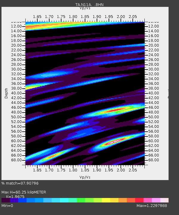
| Estimated Moho Depth: |
60.25 km |
| Estimated Crust Vp/Vs: |
1.97 |
| Assumed Crust Vp: |
6.276 km/s |
| Estimated Crust Vs: |
3.19 km/s |
| Estimated Crust Poisson's Ratio: |
0.33 |
|
| Radial Match: |
87.90796 % |
| Radial Bump: |
400 |
| Transverse Match: |
81.75261 % |
| Transverse Bump: |
400 |
| SOD ConfigId: |
2564 |
| Insert Time: |
2010-03-07 01:51:04.817 +0000 |
| GWidth: |
2.5 |
| Max Bumps: |
400 |
| Tol: |
0.001 |
|
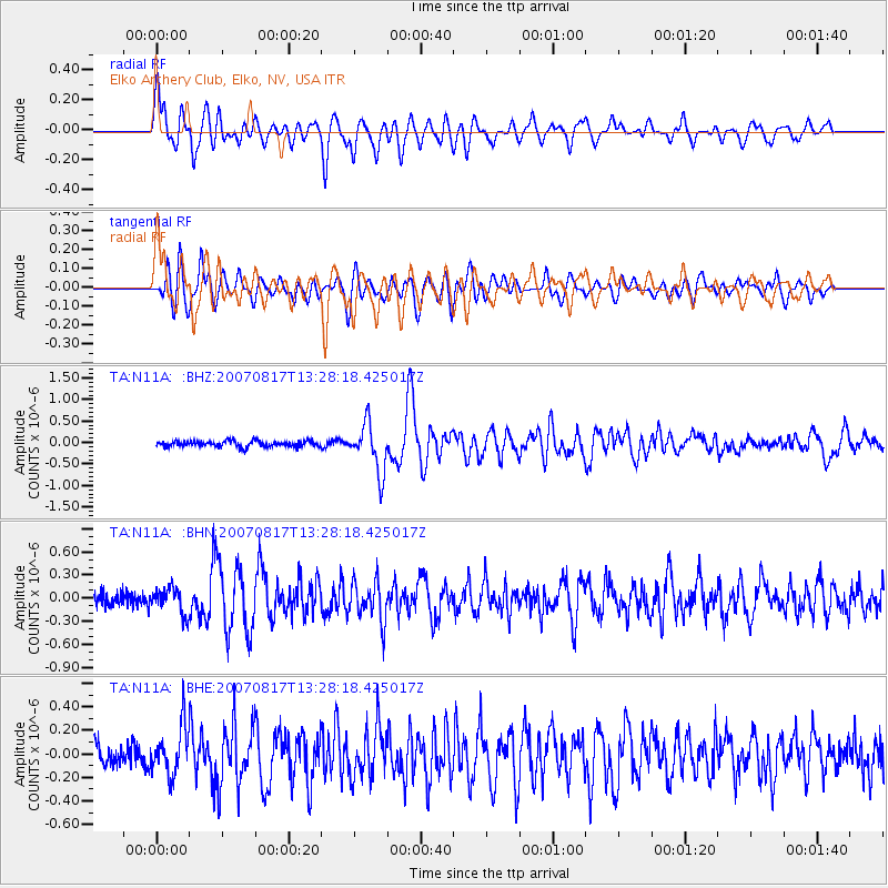
Signal To Noise
| Channel | StoN | STA | LTA |
| TA:N11A: :BHN:20070817T13:28:18.425017Z | 2.1155906 | 1.6457723E-7 | 7.779257E-8 |
| TA:N11A: :BHE:20070817T13:28:18.425017Z | 2.3071673 | 2.063553E-7 | 8.944098E-8 |
| TA:N11A: :BHZ:20070817T13:28:18.425017Z | 8.337565 | 5.592855E-7 | 6.7080194E-8 |
| Arrivals |
| Ps | 9.6 SECOND |
| PpPs | 27 SECOND |
| PsPs/PpSs | 37 SECOND |


