You are here: Home > Network List > TA - USArray Transportable Network (new EarthScope stations) Stations List
> Station M31M Drury Creek, Yukon, CA > Earthquake Result Viewer
M31M Drury Creek, Yukon, CA - Earthquake Result Viewer
| Earthquake location: |
Halmahera, Indonesia |
| Earthquake latitude/longitude: |
-0.8/127.8 |
| Earthquake time(UTC): |
2019/07/14 (195) 09:43:46 GMT |
| Earthquake Depth: |
10 km |
| Earthquake Magnitude: |
5.8 Mww |
| Earthquake Catalog/Contributor: |
NEIC PDE/us |
|
| Network: |
TA USArray Transportable Network (new EarthScope stations) |
| Station: |
M31M Drury Creek, Yukon, CA |
| Lat/Lon: |
62.20 N/134.39 W |
| Elevation: |
639 m |
|
| Distance: |
94.4 deg |
| Az: |
27.759 deg |
| Baz: |
276.586 deg |
| Ray Param: |
0.041061472 |
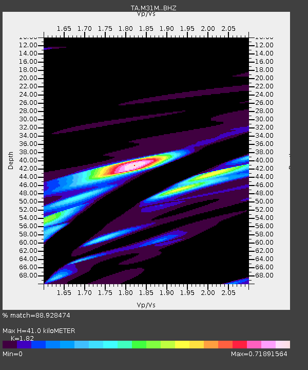
| Estimated Moho Depth: |
41.0 km |
| Estimated Crust Vp/Vs: |
1.82 |
| Assumed Crust Vp: |
6.419 km/s |
| Estimated Crust Vs: |
3.527 km/s |
| Estimated Crust Poisson's Ratio: |
0.28 |
|
| Radial Match: |
88.928474 % |
| Radial Bump: |
400 |
| Transverse Match: |
36.543217 % |
| Transverse Bump: |
274 |
| SOD ConfigId: |
19053131 |
| Insert Time: |
2019-07-28 09:46:36.378 +0000 |
| GWidth: |
2.5 |
| Max Bumps: |
400 |
| Tol: |
0.001 |
|
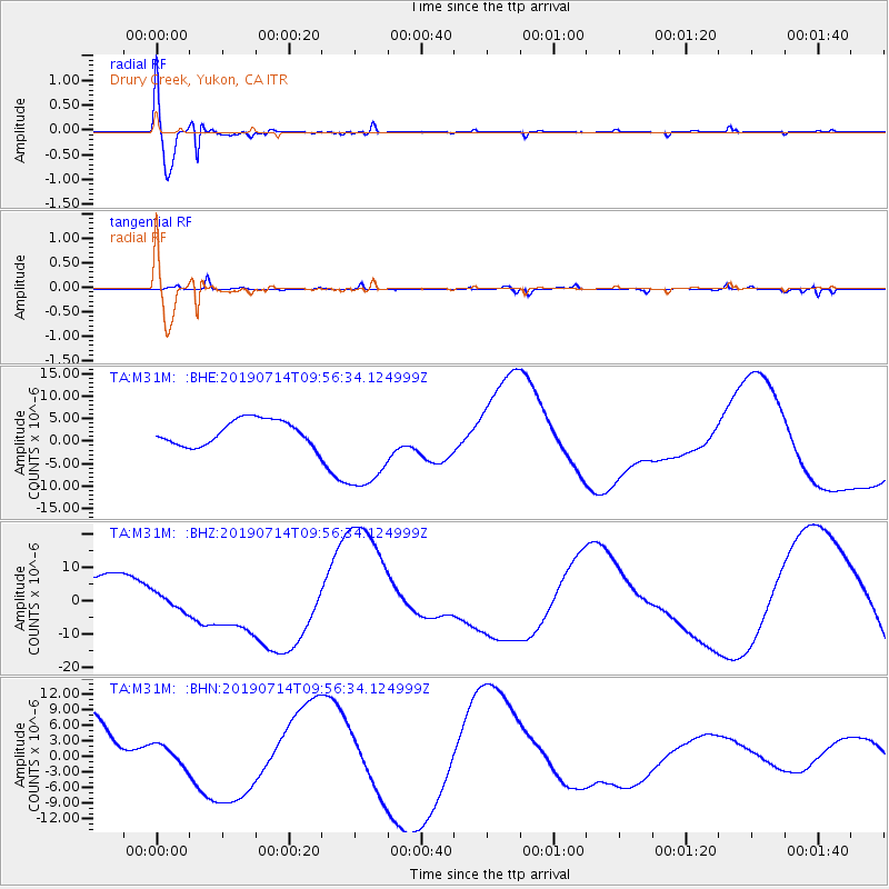
Signal To Noise
| Channel | StoN | STA | LTA |
| TA:M31M: :BHZ:20190714T09:56:34.124999Z | 0.5426922 | 2.7527108E-6 | 5.0723243E-6 |
| TA:M31M: :BHN:20190714T09:56:34.124999Z | 0.30043262 | 1.9726874E-6 | 6.5661557E-6 |
| TA:M31M: :BHE:20190714T09:56:34.124999Z | 3.8402503 | 1.0662208E-5 | 2.7764358E-6 |
| Arrivals |
| Ps | 5.3 SECOND |
| PpPs | 18 SECOND |
| PsPs/PpSs | 23 SECOND |


