You are here: Home > Network List > TJ - Tajikistan National Seismic Network Stations List
> Station GARM Garm, Tajikistan > Earthquake Result Viewer
GARM Garm, Tajikistan - Earthquake Result Viewer
| Earthquake location: |
Halmahera, Indonesia |
| Earthquake latitude/longitude: |
-0.8/127.8 |
| Earthquake time(UTC): |
2019/07/14 (195) 09:43:46 GMT |
| Earthquake Depth: |
10 km |
| Earthquake Magnitude: |
5.8 Mww |
| Earthquake Catalog/Contributor: |
NEIC PDE/us |
|
| Network: |
TJ Tajikistan National Seismic Network |
| Station: |
GARM Garm, Tajikistan |
| Lat/Lon: |
39.00 N/70.32 E |
| Elevation: |
1305 m |
|
| Distance: |
65.7 deg |
| Az: |
313.919 deg |
| Baz: |
112.43 deg |
| Ray Param: |
0.05807225 |
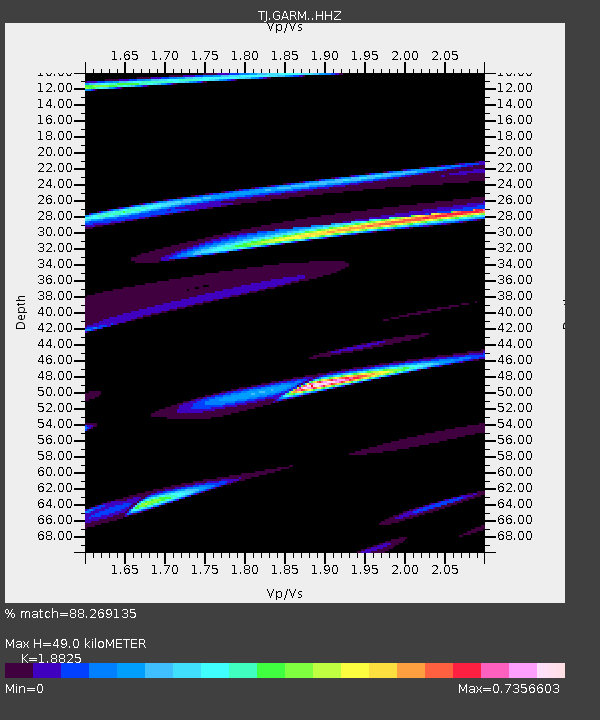
| Estimated Moho Depth: |
49.0 km |
| Estimated Crust Vp/Vs: |
1.88 |
| Assumed Crust Vp: |
6.306 km/s |
| Estimated Crust Vs: |
3.35 km/s |
| Estimated Crust Poisson's Ratio: |
0.30 |
|
| Radial Match: |
88.269135 % |
| Radial Bump: |
400 |
| Transverse Match: |
59.972713 % |
| Transverse Bump: |
194 |
| SOD ConfigId: |
19053131 |
| Insert Time: |
2019-07-28 09:46:46.641 +0000 |
| GWidth: |
2.5 |
| Max Bumps: |
400 |
| Tol: |
0.001 |
|
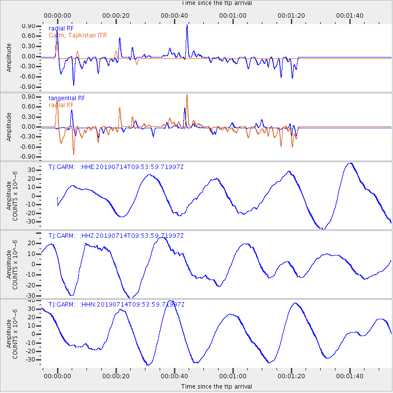
Signal To Noise
| Channel | StoN | STA | LTA |
| TJ:GARM: :HHZ:20190714T09:53:59.71997Z | 2.444227 | 1.7666138E-5 | 7.2277E-6 |
| TJ:GARM: :HHN:20190714T09:53:59.71997Z | 0.33205175 | 9.723841E-6 | 2.9284112E-5 |
| TJ:GARM: :HHE:20190714T09:53:59.71997Z | 2.0841649 | 2.469777E-5 | 1.18502E-5 |
| Arrivals |
| Ps | 7.1 SECOND |
| PpPs | 22 SECOND |
| PsPs/PpSs | 29 SECOND |


