You are here: Home > Network List > TA - USArray Transportable Network (new EarthScope stations) Stations List
> Station N11A Elko Archery Club, Elko, NV, USA > Earthquake Result Viewer
N11A Elko Archery Club, Elko, NV, USA - Earthquake Result Viewer
| Earthquake location: |
Guatemala |
| Earthquake latitude/longitude: |
14.4/-91.0 |
| Earthquake time(UTC): |
2007/07/23 (204) 22:30:08 GMT |
| Earthquake Depth: |
113 km |
| Earthquake Magnitude: |
5.5 MW, 5.3 MB, 5.5 MW |
| Earthquake Catalog/Contributor: |
WHDF/NEIC |
|
| Network: |
TA USArray Transportable Network (new EarthScope stations) |
| Station: |
N11A Elko Archery Club, Elko, NV, USA |
| Lat/Lon: |
40.82 N/115.74 W |
| Elevation: |
1643 m |
|
| Distance: |
34.1 deg |
| Az: |
325.385 deg |
| Baz: |
133.506 deg |
| Ray Param: |
0.0775742 |
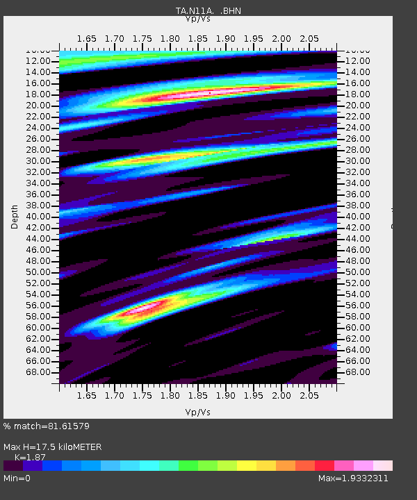
| Estimated Moho Depth: |
17.5 km |
| Estimated Crust Vp/Vs: |
1.87 |
| Assumed Crust Vp: |
6.276 km/s |
| Estimated Crust Vs: |
3.356 km/s |
| Estimated Crust Poisson's Ratio: |
0.30 |
|
| Radial Match: |
81.61579 % |
| Radial Bump: |
400 |
| Transverse Match: |
84.2251 % |
| Transverse Bump: |
400 |
| SOD ConfigId: |
2564 |
| Insert Time: |
2010-03-07 01:51:26.270 +0000 |
| GWidth: |
2.5 |
| Max Bumps: |
400 |
| Tol: |
0.001 |
|

Signal To Noise
| Channel | StoN | STA | LTA |
| TA:N11A: :BHN:20070723T22:36:11.59801Z | 1.6393194 | 3.268687E-7 | 1.9939293E-7 |
| TA:N11A: :BHE:20070723T22:36:11.59801Z | 3.0843368 | 4.8262893E-7 | 1.5647738E-7 |
| TA:N11A: :BHZ:20070723T22:36:11.59801Z | 6.05779 | 9.17543E-7 | 1.5146497E-7 |
| Arrivals |
| Ps | 2.6 SECOND |
| PpPs | 7.5 SECOND |
| PsPs/PpSs | 10 SECOND |


