You are here: Home > Network List > TA - USArray Transportable Network (new EarthScope stations) Stations List
> Station N11A Elko Archery Club, Elko, NV, USA > Earthquake Result Viewer
N11A Elko Archery Club, Elko, NV, USA - Earthquake Result Viewer

| Earthquake location: |
Near West Coast Of Honshu, Japan |
| Earthquake latitude/longitude: |
37.5/138.5 |
| Earthquake time(UTC): |
2007/07/16 (197) 06:37:40 GMT |
| Earthquake Depth: |
15 km |
| Earthquake Magnitude: |
5.7 MB, 5.1 MS, 5.7 MW, 5.6 MW |
| Earthquake Catalog/Contributor: |
WHDF/NEIC |
|
| Network: |
TA USArray Transportable Network (new EarthScope stations) |
| Station: |
N11A Elko Archery Club, Elko, NV, USA |
| Lat/Lon: |
40.82 N/115.74 W |
| Elevation: |
1643 m |
|
| Distance: |
76.7 deg |
| Az: |
48.634 deg |
| Baz: |
308.148 deg |
| Ray Param: |
0.050822563 |
| Estimated Moho Depth: |
24.0 km |
| Estimated Crust Vp/Vs: |
1.75 |
| Assumed Crust Vp: |
6.276 km/s |
| Estimated Crust Vs: |
3.581 km/s |
| Estimated Crust Poisson's Ratio: |
0.26 |
|
| Radial Match: |
83.66361 % |
| Radial Bump: |
400 |
| Transverse Match: |
76.80759 % |
| Transverse Bump: |
400 |
| SOD ConfigId: |
2564 |
| Insert Time: |
2010-03-07 01:51:30.462 +0000 |
| GWidth: |
2.5 |
| Max Bumps: |
400 |
| Tol: |
0.001 |
|
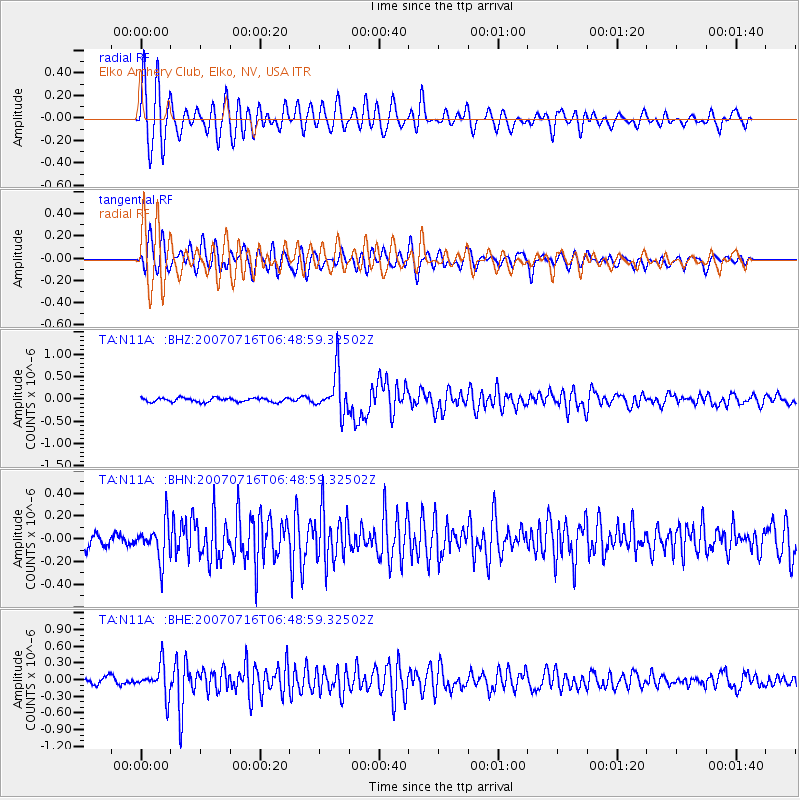
Signal To Noise
| Channel | StoN | STA | LTA |
| TA:N11A: :BHN:20070716T06:48:59.32502Z | 3.3443077 | 1.6449268E-7 | 4.9185868E-8 |
| TA:N11A: :BHE:20070716T06:48:59.32502Z | 4.817709 | 2.747376E-7 | 5.7026604E-8 |
| TA:N11A: :BHZ:20070716T06:48:59.32502Z | 10.116252 | 4.639196E-7 | 4.585884E-8 |
| Arrivals |
| Ps | 3.0 SECOND |
| PpPs | 10 SECOND |
| PsPs/PpSs | 13 SECOND |


