You are here: Home > Network List > TA - USArray Transportable Network (new EarthScope stations) Stations List
> Station N11A Elko Archery Club, Elko, NV, USA > Earthquake Result Viewer
N11A Elko Archery Club, Elko, NV, USA - Earthquake Result Viewer
| Earthquake location: |
East Of Kuril Islands |
| Earthquake latitude/longitude: |
46.2/154.5 |
| Earthquake time(UTC): |
2007/01/13 (013) 04:23:21 GMT |
| Earthquake Depth: |
10 km |
| Earthquake Magnitude: |
7.3 MB, 8.2 MS, 8.1 MW, 7.9 MW |
| Earthquake Catalog/Contributor: |
WHDF/NEIC |
|
| Network: |
TA USArray Transportable Network (new EarthScope stations) |
| Station: |
N11A Elko Archery Club, Elko, NV, USA |
| Lat/Lon: |
40.82 N/115.74 W |
| Elevation: |
1643 m |
|
| Distance: |
61.9 deg |
| Az: |
59.368 deg |
| Baz: |
308.11 deg |
| Ray Param: |
0.06058691 |
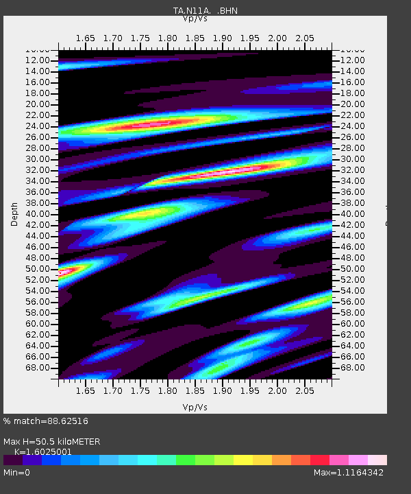
| Estimated Moho Depth: |
50.5 km |
| Estimated Crust Vp/Vs: |
1.60 |
| Assumed Crust Vp: |
6.276 km/s |
| Estimated Crust Vs: |
3.916 km/s |
| Estimated Crust Poisson's Ratio: |
0.18 |
|
| Radial Match: |
88.62516 % |
| Radial Bump: |
400 |
| Transverse Match: |
72.335014 % |
| Transverse Bump: |
400 |
| SOD ConfigId: |
2564 |
| Insert Time: |
2010-03-07 01:52:08.388 +0000 |
| GWidth: |
2.5 |
| Max Bumps: |
400 |
| Tol: |
0.001 |
|
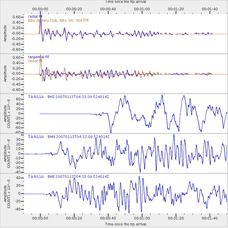
Signal To Noise
| Channel | StoN | STA | LTA |
| TA:N11A: :BHN:20070113T04:33:09.524014Z | 6.770648 | 6.9138275E-7 | 1.0211471E-7 |
| TA:N11A: :BHE:20070113T04:33:09.524014Z | 4.784117 | 9.305899E-7 | 1.9451653E-7 |
| TA:N11A: :BHZ:20070113T04:33:09.524014Z | 9.639739 | 2.2040492E-6 | 2.28642E-7 |
| Arrivals |
| Ps | 5.1 SECOND |
| PpPs | 20 SECOND |
| PsPs/PpSs | 25 SECOND |


