You are here: Home > Network List > TA - USArray Transportable Network (new EarthScope stations) Stations List
> Station N11A Elko Archery Club, Elko, NV, USA > Earthquake Result Viewer
N11A Elko Archery Club, Elko, NV, USA - Earthquake Result Viewer
| Earthquake location: |
Near East Coast Of Kamchatka |
| Earthquake latitude/longitude: |
55.6/161.7 |
| Earthquake time(UTC): |
2006/08/17 (229) 11:11:35 GMT |
| Earthquake Depth: |
55 km |
| Earthquake Magnitude: |
6.1 MB, 5.7 MW, 5.7 MW |
| Earthquake Catalog/Contributor: |
WHDF/NEIC |
|
| Network: |
TA USArray Transportable Network (new EarthScope stations) |
| Station: |
N11A Elko Archery Club, Elko, NV, USA |
| Lat/Lon: |
40.82 N/115.74 W |
| Elevation: |
1643 m |
|
| Distance: |
53.7 deg |
| Az: |
69.017 deg |
| Baz: |
315.741 deg |
| Ray Param: |
0.0657707 |
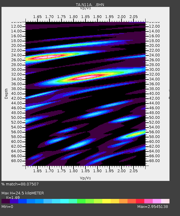
| Estimated Moho Depth: |
24.5 km |
| Estimated Crust Vp/Vs: |
1.69 |
| Assumed Crust Vp: |
6.276 km/s |
| Estimated Crust Vs: |
3.713 km/s |
| Estimated Crust Poisson's Ratio: |
0.23 |
|
| Radial Match: |
88.07507 % |
| Radial Bump: |
400 |
| Transverse Match: |
85.74423 % |
| Transverse Bump: |
400 |
| SOD ConfigId: |
2564 |
| Insert Time: |
2010-03-07 01:52:21.300 +0000 |
| GWidth: |
2.5 |
| Max Bumps: |
400 |
| Tol: |
0.001 |
|

Signal To Noise
| Channel | StoN | STA | LTA |
| TA:N11A: :BHN:20060817T11:20:21.349021Z | 4.212903 | 7.238564E-7 | 1.718189E-7 |
| TA:N11A: :BHE:20060817T11:20:21.349021Z | 10.143069 | 1.1150925E-6 | 1.09936394E-7 |
| TA:N11A: :BHZ:20060817T11:20:21.349021Z | 15.956773 | 1.4473715E-6 | 9.0705775E-8 |
| Arrivals |
| Ps | 2.8 SECOND |
| PpPs | 10.0 SECOND |
| PsPs/PpSs | 13 SECOND |


