You are here: Home > Network List > TA - USArray Transportable Network (new EarthScope stations) Stations List
> Station N11A Elko Archery Club, Elko, NV, USA > Earthquake Result Viewer
N11A Elko Archery Club, Elko, NV, USA - Earthquake Result Viewer
| Earthquake location: |
Fox Islands, Aleutian Islands |
| Earthquake latitude/longitude: |
54.0/-166.4 |
| Earthquake time(UTC): |
2006/09/01 (244) 12:04:22 GMT |
| Earthquake Depth: |
76 km |
| Earthquake Magnitude: |
5.8 MB, 5.9 MW |
| Earthquake Catalog/Contributor: |
WHDF/NEIC |
|
| Network: |
TA USArray Transportable Network (new EarthScope stations) |
| Station: |
N11A Elko Archery Club, Elko, NV, USA |
| Lat/Lon: |
40.82 N/115.74 W |
| Elevation: |
1643 m |
|
| Distance: |
35.9 deg |
| Az: |
90.345 deg |
| Baz: |
308.886 deg |
| Ray Param: |
0.07672415 |
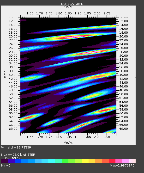
| Estimated Moho Depth: |
28.0 km |
| Estimated Crust Vp/Vs: |
1.97 |
| Assumed Crust Vp: |
6.276 km/s |
| Estimated Crust Vs: |
3.19 km/s |
| Estimated Crust Poisson's Ratio: |
0.33 |
|
| Radial Match: |
82.73539 % |
| Radial Bump: |
400 |
| Transverse Match: |
72.90101 % |
| Transverse Bump: |
400 |
| SOD ConfigId: |
2665 |
| Insert Time: |
2010-03-07 01:52:37.041 +0000 |
| GWidth: |
2.5 |
| Max Bumps: |
400 |
| Tol: |
0.001 |
|
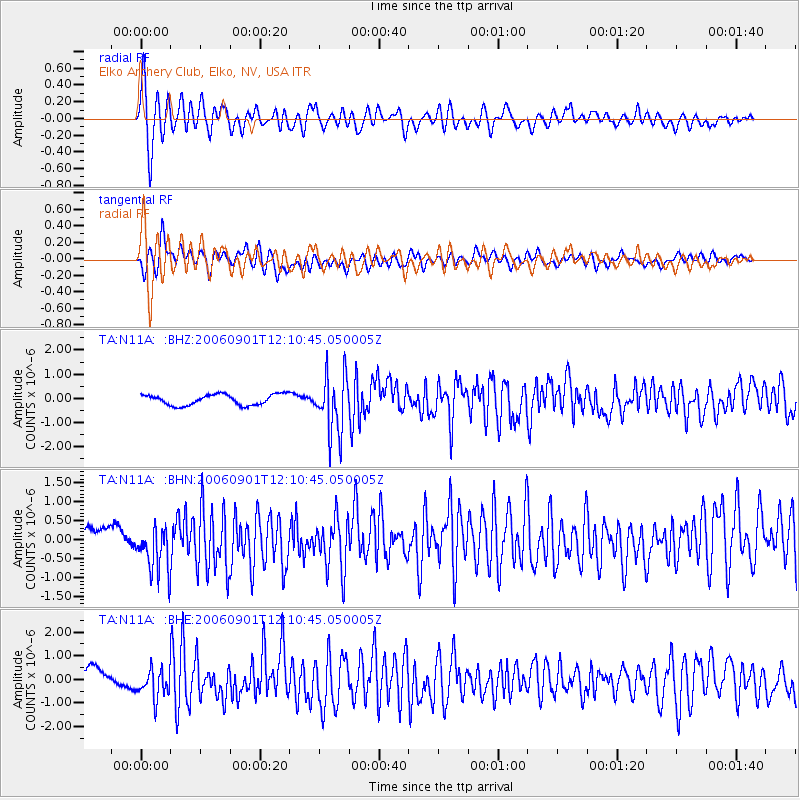
Signal To Noise
| Channel | StoN | STA | LTA |
| TA:N11A: :BHN:20060901T12:10:45.050005Z | 2.8810284 | 6.4347284E-7 | 2.2334832E-7 |
| TA:N11A: :BHE:20060901T12:10:45.050005Z | 1.7597058 | 6.2033223E-7 | 3.525204E-7 |
| TA:N11A: :BHZ:20060901T12:10:45.050005Z | 5.5201206 | 1.2202323E-6 | 2.2105174E-7 |
| Arrivals |
| Ps | 4.6 SECOND |
| PpPs | 12 SECOND |
| PsPs/PpSs | 17 SECOND |


