You are here: Home > Network List > TA - USArray Transportable Network (new EarthScope stations) Stations List
> Station N11A Elko Archery Club, Elko, NV, USA > Earthquake Result Viewer
N11A Elko Archery Club, Elko, NV, USA - Earthquake Result Viewer
| Earthquake location: |
Off Coast Of Chiapas, Mexico |
| Earthquake latitude/longitude: |
15.0/-94.2 |
| Earthquake time(UTC): |
2006/06/27 (178) 13:03:12 GMT |
| Earthquake Depth: |
29 km |
| Earthquake Magnitude: |
5.4 MB, 5.5 MS, 5.8 MW, 5.8 MW |
| Earthquake Catalog/Contributor: |
WHDF/NEIC |
|
| Network: |
TA USArray Transportable Network (new EarthScope stations) |
| Station: |
N11A Elko Archery Club, Elko, NV, USA |
| Lat/Lon: |
40.82 N/115.74 W |
| Elevation: |
1643 m |
|
| Distance: |
31.9 deg |
| Az: |
328.115 deg |
| Baz: |
137.726 deg |
| Ray Param: |
0.078855366 |
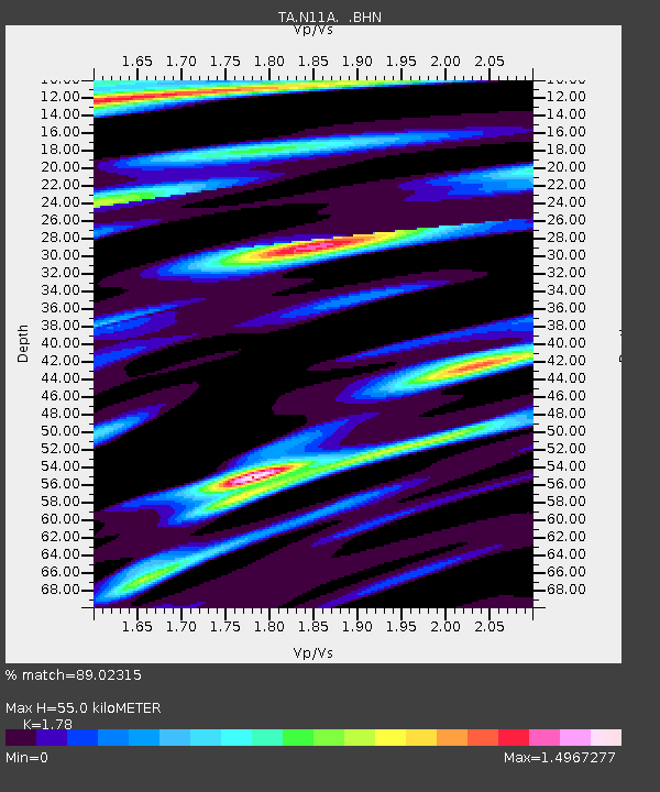
| Estimated Moho Depth: |
55.0 km |
| Estimated Crust Vp/Vs: |
1.78 |
| Assumed Crust Vp: |
6.276 km/s |
| Estimated Crust Vs: |
3.526 km/s |
| Estimated Crust Poisson's Ratio: |
0.27 |
|
| Radial Match: |
89.02315 % |
| Radial Bump: |
400 |
| Transverse Match: |
83.71461 % |
| Transverse Bump: |
400 |
| SOD ConfigId: |
2665 |
| Insert Time: |
2010-03-07 01:52:54.968 +0000 |
| GWidth: |
2.5 |
| Max Bumps: |
400 |
| Tol: |
0.001 |
|

Signal To Noise
| Channel | StoN | STA | LTA |
| TA:N11A: :BHN:20060627T13:09:04.250006Z | 3.4794528 | 4.3442475E-7 | 1.2485432E-7 |
| TA:N11A: :BHE:20060627T13:09:04.250006Z | 3.2215316 | 4.0073684E-7 | 1.2439327E-7 |
| TA:N11A: :BHZ:20060627T13:09:04.250006Z | 10.333322 | 9.941853E-7 | 9.621158E-8 |
| Arrivals |
| Ps | 7.4 SECOND |
| PpPs | 23 SECOND |
| PsPs/PpSs | 30 SECOND |


