You are here: Home > Network List > TA - USArray Transportable Network (new EarthScope stations) Stations List
> Station N11A Elko Archery Club, Elko, NV, USA > Earthquake Result Viewer
N11A Elko Archery Club, Elko, NV, USA - Earthquake Result Viewer
| Earthquake location: |
New Britain Region, P.N.G. |
| Earthquake latitude/longitude: |
-5.7/151.1 |
| Earthquake time(UTC): |
2006/05/28 (148) 03:12:08 GMT |
| Earthquake Depth: |
34 km |
| Earthquake Magnitude: |
5.9 MB, 6.6 MS, 6.5 MW, 6.4 MW |
| Earthquake Catalog/Contributor: |
WHDF/NEIC |
|
| Network: |
TA USArray Transportable Network (new EarthScope stations) |
| Station: |
N11A Elko Archery Club, Elko, NV, USA |
| Lat/Lon: |
40.82 N/115.74 W |
| Elevation: |
1643 m |
|
| Distance: |
96.1 deg |
| Az: |
49.651 deg |
| Baz: |
267.706 deg |
| Ray Param: |
0.04059919 |
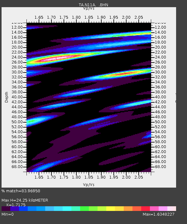
| Estimated Moho Depth: |
24.25 km |
| Estimated Crust Vp/Vs: |
1.72 |
| Assumed Crust Vp: |
6.276 km/s |
| Estimated Crust Vs: |
3.654 km/s |
| Estimated Crust Poisson's Ratio: |
0.24 |
|
| Radial Match: |
83.96958 % |
| Radial Bump: |
400 |
| Transverse Match: |
78.34351 % |
| Transverse Bump: |
400 |
| SOD ConfigId: |
2669 |
| Insert Time: |
2010-03-07 01:53:06.047 +0000 |
| GWidth: |
2.5 |
| Max Bumps: |
400 |
| Tol: |
0.001 |
|

Signal To Noise
| Channel | StoN | STA | LTA |
| TA:N11A: :BHN:20060528T03:25:01.325002Z | 0.46513638 | 5.512406E-8 | 1.1851161E-7 |
| TA:N11A: :BHE:20060528T03:25:01.325002Z | 2.2567606 | 2.4123906E-7 | 1.06896174E-7 |
| TA:N11A: :BHZ:20060528T03:25:01.325002Z | 6.8569813 | 5.1191313E-7 | 7.465576E-8 |
| Arrivals |
| Ps | 2.8 SECOND |
| PpPs | 10 SECOND |
| PsPs/PpSs | 13 SECOND |


