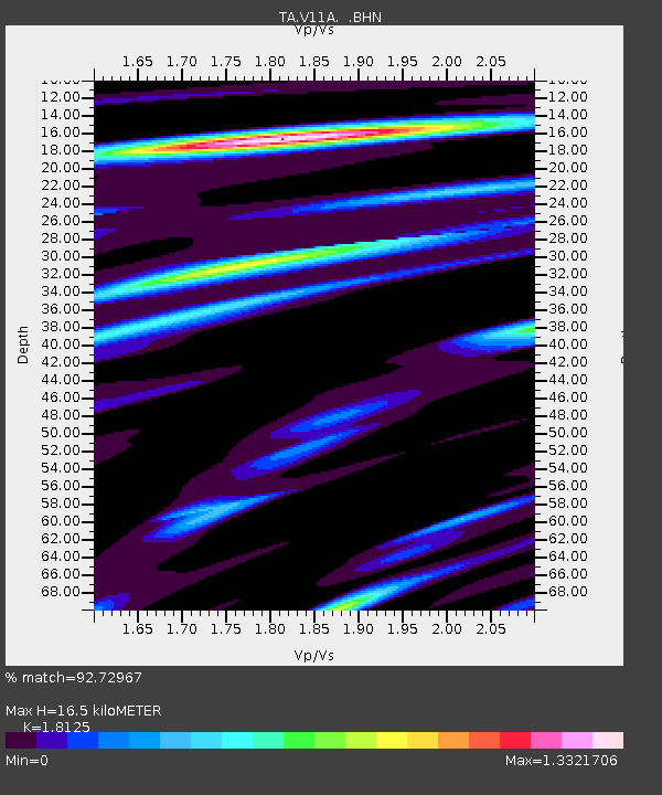
V11A Goodsprings, NV, USA - Earthquake Result Viewer
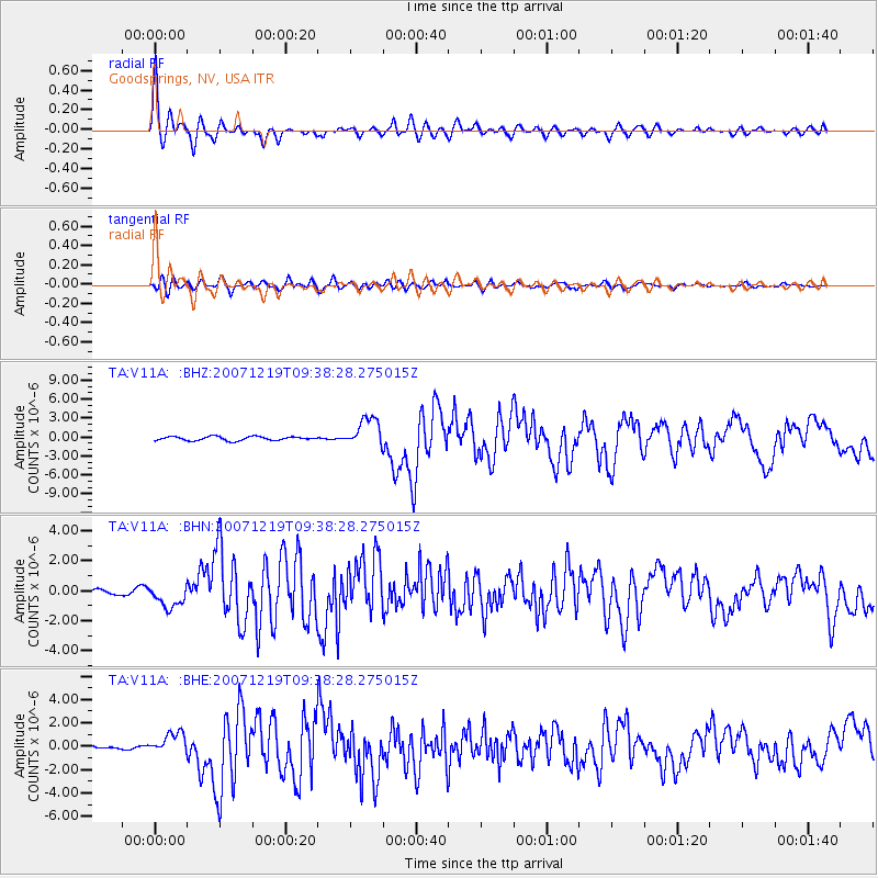
Earthquake location: Andreanof Islands, Aleutian Is.
Earthquake latitude/longitude: 51.4/-179.5
Earthquake time(UTC): 2007/12/19 (353) 09:30:27 GMT
Earthquake Depth: 29 km
Earthquake Magnitude: 6.4 MB, 7.1 MS, 7.1 MW, 7.0 MW
Earthquake Catalog/Contributor: WHDF/NEIC
Network: TA USArray Transportable Network (new EarthScope stations)
Station: V11A Goodsprings, NV, USA
Lat/Lon: 35.84 N/115.43 W
Elevation: 1117 m
Distance: 47.4 deg
Az: 83.067 deg
Baz: 310.009 deg
Ray Param: 0.06995075
Estimated Moho Depth: 16.5 km
Estimated Crust Vp/Vs: 1.81
Assumed Crust Vp: 6.276 km/s
Estimated Crust Vs: 3.463 km/s
Estimated Crust Poisson's Ratio: 0.28
Radial Match: 92.72967 %
Radial Bump: 400
Transverse Match: 75.329765 %
Transverse Bump: 400
SOD ConfigId: 2564
Insert Time: 2010-03-07 01:53:23.283 +0000
GWidth: 2.5
Max Bumps: 400
Tol: 0.001

Signal To Noise

ChannelStoNSTALTA
TA:V11A: :BHN:20071219T09:38:28.275015Z3.25866567.731283E-72.3725303E-7
TA:V11A: :BHE:20071219T09:38:28.275015Z5.4696879.4582384E-71.7292102E-7
TA:V11A: :BHZ:20071219T09:38:28.275015Z7.52587272.3204566E-63.0833058E-7
Arrivals
Ps2.3 SECOND
PpPs7.0 SECOND
PsPs/PpSs9.2 SECOND