You are here: Home > Network List > BK - Berkeley Digital Seismograph Network Stations List
> Station HUMO Hull Mountain, OR > Earthquake Result Viewer
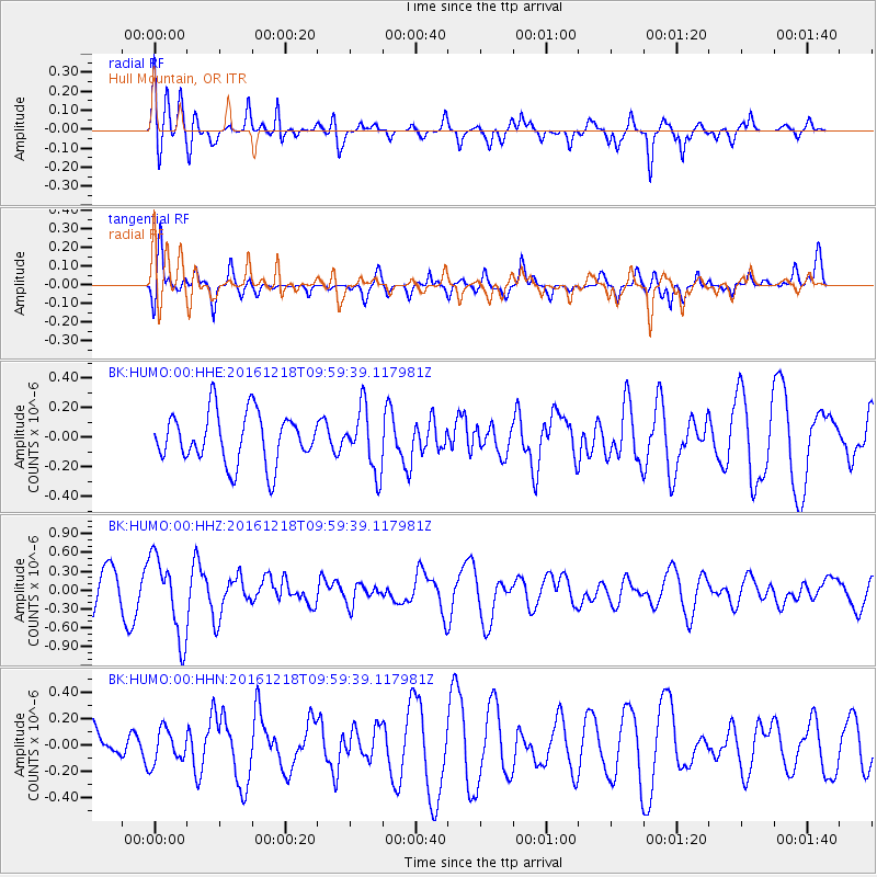
HUMO Hull Mountain, OR - Earthquake Result Viewer
*The percent match for this event was below the threshold and hence no stack was calculated.
| Earthquake location: |
W. Caroline Islands, Micronesia |
| Earthquake latitude/longitude: |
8.3/137.7 |
| Earthquake time(UTC): |
2016/12/18 (353) 09:47:08 GMT |
| Earthquake Depth: |
29 km |
| Earthquake Magnitude: |
6.5 Mi |
| Earthquake Catalog/Contributor: |
NEIC PDE/at |
|
| Network: |
BK Berkeley Digital Seismograph Network |
| Station: |
HUMO Hull Mountain, OR |
| Lat/Lon: |
42.61 N/122.96 W |
| Elevation: |
555 m |
|
| Distance: |
91.3 deg |
| Az: |
46.774 deg |
| Baz: |
282.374 deg |
| Ray Param: |
$rayparam |
*The percent match for this event was below the threshold and hence was not used in the summary stack. |
|
| Radial Match: |
54.219975 % |
| Radial Bump: |
391 |
| Transverse Match: |
47.727745 % |
| Transverse Bump: |
323 |
| SOD ConfigId: |
1894071 |
| Insert Time: |
2017-01-01 09:48:15.405 +0000 |
| GWidth: |
2.5 |
| Max Bumps: |
400 |
| Tol: |
0.001 |
|
Signal To Noise
| Channel | StoN | STA | LTA |
| BK:HUMO:00:HHZ:20161218T09:59:39.117981Z | 2.0431056 | 6.3647036E-7 | 3.1152103E-7 |
| BK:HUMO:00:HHN:20161218T09:59:39.117981Z | 0.523015 | 1.2943956E-7 | 2.4748726E-7 |
| BK:HUMO:00:HHE:20161218T09:59:39.117981Z | 1.2125477 | 2.0689772E-7 | 1.706306E-7 |
| Arrivals |
| Ps | |
| PpPs | |
| PsPs/PpSs | |


