You are here: Home > Network List > TA - USArray Transportable Network (new EarthScope stations) Stations List
> Station V11A Goodsprings, NV, USA > Earthquake Result Viewer
V11A Goodsprings, NV, USA - Earthquake Result Viewer
| Earthquake location: |
Solomon Islands |
| Earthquake latitude/longitude: |
-10.9/162.1 |
| Earthquake time(UTC): |
2007/11/27 (331) 11:49:58 GMT |
| Earthquake Depth: |
16 km |
| Earthquake Magnitude: |
5.9 MB, 6.7 MS, 6.6 MW, 6.4 MW |
| Earthquake Catalog/Contributor: |
WHDF/NEIC |
|
| Network: |
TA USArray Transportable Network (new EarthScope stations) |
| Station: |
V11A Goodsprings, NV, USA |
| Lat/Lon: |
35.84 N/115.43 W |
| Elevation: |
1117 m |
|
| Distance: |
90.3 deg |
| Az: |
53.653 deg |
| Baz: |
256.77 deg |
| Ray Param: |
0.041684184 |
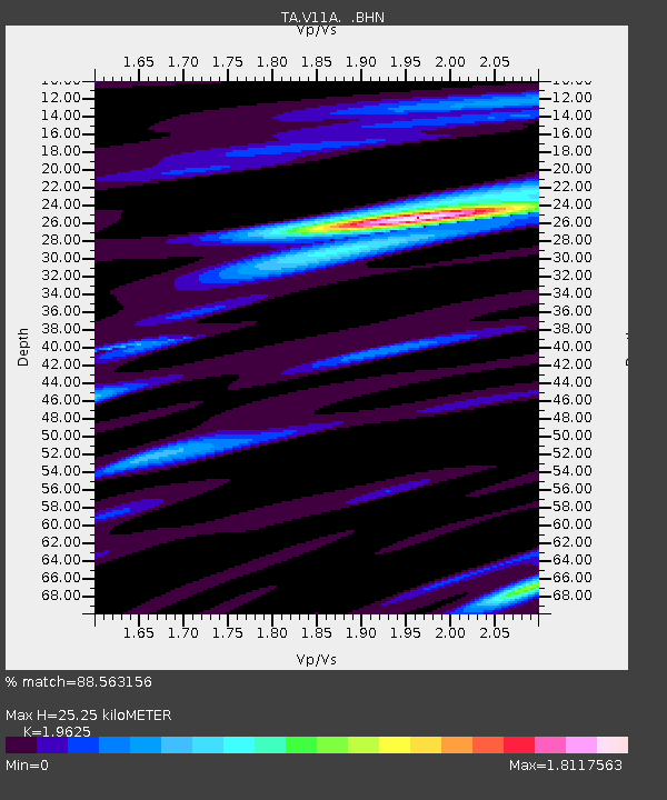
| Estimated Moho Depth: |
25.25 km |
| Estimated Crust Vp/Vs: |
1.96 |
| Assumed Crust Vp: |
6.276 km/s |
| Estimated Crust Vs: |
3.198 km/s |
| Estimated Crust Poisson's Ratio: |
0.32 |
|
| Radial Match: |
88.563156 % |
| Radial Bump: |
400 |
| Transverse Match: |
75.12131 % |
| Transverse Bump: |
400 |
| SOD ConfigId: |
2564 |
| Insert Time: |
2010-03-07 01:53:27.539 +0000 |
| GWidth: |
2.5 |
| Max Bumps: |
400 |
| Tol: |
0.001 |
|
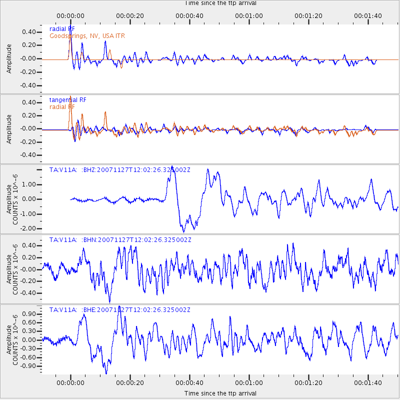
Signal To Noise
| Channel | StoN | STA | LTA |
| TA:V11A: :BHN:20071127T12:02:26.325002Z | 1.3583455 | 1.553337E-7 | 1.1435507E-7 |
| TA:V11A: :BHE:20071127T12:02:26.325002Z | 3.8898032 | 4.5691763E-7 | 1.1746548E-7 |
| TA:V11A: :BHZ:20071127T12:02:26.325002Z | 11.794145 | 1.1495216E-6 | 9.746545E-8 |
| Arrivals |
| Ps | 3.9 SECOND |
| PpPs | 12 SECOND |
| PsPs/PpSs | 16 SECOND |


