You are here: Home > Network List > TA - USArray Transportable Network (new EarthScope stations) Stations List
> Station V11A Goodsprings, NV, USA > Earthquake Result Viewer
V11A Goodsprings, NV, USA - Earthquake Result Viewer
| Earthquake location: |
Southeast Of Loyalty Islands |
| Earthquake latitude/longitude: |
-21.2/169.4 |
| Earthquake time(UTC): |
2007/09/28 (271) 01:01:48 GMT |
| Earthquake Depth: |
10 km |
| Earthquake Magnitude: |
5.8 MB, 6.4 MS, 6.3 MW, 6.2 MW |
| Earthquake Catalog/Contributor: |
WHDF/NEIC |
|
| Network: |
TA USArray Transportable Network (new EarthScope stations) |
| Station: |
V11A Goodsprings, NV, USA |
| Lat/Lon: |
35.84 N/115.43 W |
| Elevation: |
1117 m |
|
| Distance: |
90.9 deg |
| Az: |
51.786 deg |
| Baz: |
244.462 deg |
| Ray Param: |
0.04163902 |
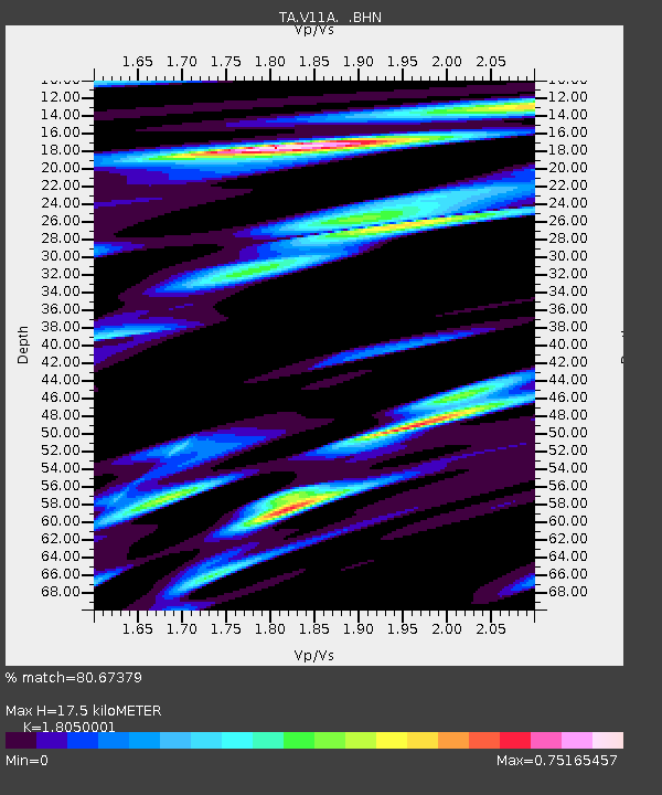
| Estimated Moho Depth: |
17.5 km |
| Estimated Crust Vp/Vs: |
1.81 |
| Assumed Crust Vp: |
6.276 km/s |
| Estimated Crust Vs: |
3.477 km/s |
| Estimated Crust Poisson's Ratio: |
0.28 |
|
| Radial Match: |
80.67379 % |
| Radial Bump: |
400 |
| Transverse Match: |
65.27826 % |
| Transverse Bump: |
400 |
| SOD ConfigId: |
2564 |
| Insert Time: |
2010-03-07 01:53:45.599 +0000 |
| GWidth: |
2.5 |
| Max Bumps: |
400 |
| Tol: |
0.001 |
|
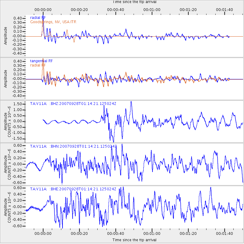
Signal To Noise
| Channel | StoN | STA | LTA |
| TA:V11A: :BHN:20070928T01:14:21.125024Z | 1.2301753 | 1.2961011E-7 | 1.0535906E-7 |
| TA:V11A: :BHE:20070928T01:14:21.125024Z | 1.7412821 | 1.5348756E-7 | 8.814629E-8 |
| TA:V11A: :BHZ:20070928T01:14:21.125024Z | 4.420293 | 4.2576227E-7 | 9.631992E-8 |
| Arrivals |
| Ps | 2.3 SECOND |
| PpPs | 7.7 SECOND |
| PsPs/PpSs | 10.0 SECOND |


