You are here: Home > Network List > TA - USArray Transportable Network (new EarthScope stations) Stations List
> Station C21K Knifeblade Ridge, AK, USA > Earthquake Result Viewer
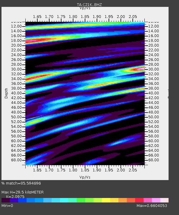
C21K Knifeblade Ridge, AK, USA - Earthquake Result Viewer
| Earthquake location: |
New Britain Region, P.N.G. |
| Earthquake latitude/longitude: |
-6.0/149.6 |
| Earthquake time(UTC): |
2019/07/15 (196) 08:21:35 GMT |
| Earthquake Depth: |
59 km |
| Earthquake Magnitude: |
6.2 Mww |
| Earthquake Catalog/Contributor: |
NEIC PDE/us |
|
| Network: |
TA USArray Transportable Network (new EarthScope stations) |
| Station: |
C21K Knifeblade Ridge, AK, USA |
| Lat/Lon: |
69.16 N/154.78 W |
| Elevation: |
409 m |
|
| Distance: |
84.0 deg |
| Az: |
17.287 deg |
| Baz: |
235.668 deg |
| Ray Param: |
0.04566105 |
| Estimated Moho Depth: |
29.5 km |
| Estimated Crust Vp/Vs: |
2.10 |
| Assumed Crust Vp: |
6.221 km/s |
| Estimated Crust Vs: |
2.966 km/s |
| Estimated Crust Poisson's Ratio: |
0.35 |
|
| Radial Match: |
85.594696 % |
| Radial Bump: |
400 |
| Transverse Match: |
73.136536 % |
| Transverse Bump: |
400 |
| SOD ConfigId: |
19053131 |
| Insert Time: |
2019-07-29 08:28:00.554 +0000 |
| GWidth: |
2.5 |
| Max Bumps: |
400 |
| Tol: |
0.001 |
|

Signal To Noise
| Channel | StoN | STA | LTA |
| TA:C21K: :BHZ:20190715T08:33:28.949973Z | 6.9788866 | 5.0890856E-7 | 7.292117E-8 |
| TA:C21K: :BHN:20190715T08:33:28.949973Z | 1.424812 | 9.262038E-8 | 6.500533E-8 |
| TA:C21K: :BHE:20190715T08:33:28.949973Z | 2.9208398 | 1.3199899E-7 | 4.5192134E-8 |
| Arrivals |
| Ps | 5.3 SECOND |
| PpPs | 14 SECOND |
| PsPs/PpSs | 20 SECOND |


