You are here: Home > Network List > TA - USArray Transportable Network (new EarthScope stations) Stations List
> Station E21K Killik River, AK, USA > Earthquake Result Viewer
E21K Killik River, AK, USA - Earthquake Result Viewer
| Earthquake location: |
New Britain Region, P.N.G. |
| Earthquake latitude/longitude: |
-6.0/149.6 |
| Earthquake time(UTC): |
2019/07/15 (196) 08:21:35 GMT |
| Earthquake Depth: |
59 km |
| Earthquake Magnitude: |
6.2 Mww |
| Earthquake Catalog/Contributor: |
NEIC PDE/us |
|
| Network: |
TA USArray Transportable Network (new EarthScope stations) |
| Station: |
E21K Killik River, AK, USA |
| Lat/Lon: |
68.44 N/153.97 W |
| Elevation: |
653 m |
|
| Distance: |
83.9 deg |
| Az: |
18.052 deg |
| Baz: |
236.504 deg |
| Ray Param: |
0.045767505 |
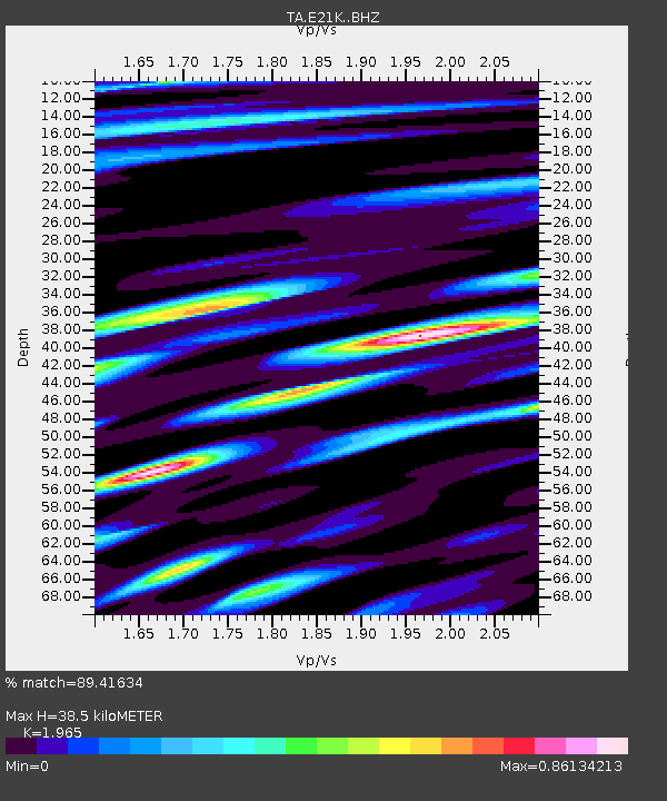
| Estimated Moho Depth: |
38.5 km |
| Estimated Crust Vp/Vs: |
1.97 |
| Assumed Crust Vp: |
6.221 km/s |
| Estimated Crust Vs: |
3.166 km/s |
| Estimated Crust Poisson's Ratio: |
0.33 |
|
| Radial Match: |
89.41634 % |
| Radial Bump: |
400 |
| Transverse Match: |
81.20115 % |
| Transverse Bump: |
400 |
| SOD ConfigId: |
19053131 |
| Insert Time: |
2019-07-29 08:28:12.276 +0000 |
| GWidth: |
2.5 |
| Max Bumps: |
400 |
| Tol: |
0.001 |
|

Signal To Noise
| Channel | StoN | STA | LTA |
| TA:E21K: :BHZ:20190715T08:33:28.149985Z | 7.762235 | 4.5308354E-7 | 5.837024E-8 |
| TA:E21K: :BHN:20190715T08:33:28.149985Z | 1.6679075 | 8.603573E-8 | 5.158304E-8 |
| TA:E21K: :BHE:20190715T08:33:28.149985Z | 3.2002146 | 1.2156463E-7 | 3.79864E-8 |
| Arrivals |
| Ps | 6.1 SECOND |
| PpPs | 18 SECOND |
| PsPs/PpSs | 24 SECOND |


