You are here: Home > Network List > TA - USArray Transportable Network (new EarthScope stations) Stations List
> Station G22K Bettles, AK, USA > Earthquake Result Viewer
G22K Bettles, AK, USA - Earthquake Result Viewer

| Earthquake location: |
New Britain Region, P.N.G. |
| Earthquake latitude/longitude: |
-6.0/149.6 |
| Earthquake time(UTC): |
2019/07/15 (196) 08:21:35 GMT |
| Earthquake Depth: |
59 km |
| Earthquake Magnitude: |
6.2 Mww |
| Earthquake Catalog/Contributor: |
NEIC PDE/us |
|
| Network: |
TA USArray Transportable Network (new EarthScope stations) |
| Station: |
G22K Bettles, AK, USA |
| Lat/Lon: |
66.92 N/151.51 W |
| Elevation: |
205 m |
|
| Distance: |
83.9 deg |
| Az: |
19.856 deg |
| Baz: |
238.975 deg |
| Ray Param: |
0.045780443 |
| Estimated Moho Depth: |
11.0 km |
| Estimated Crust Vp/Vs: |
1.79 |
| Assumed Crust Vp: |
6.577 km/s |
| Estimated Crust Vs: |
3.674 km/s |
| Estimated Crust Poisson's Ratio: |
0.27 |
|
| Radial Match: |
89.07195 % |
| Radial Bump: |
400 |
| Transverse Match: |
73.23951 % |
| Transverse Bump: |
400 |
| SOD ConfigId: |
19053131 |
| Insert Time: |
2019-07-29 08:28:27.499 +0000 |
| GWidth: |
2.5 |
| Max Bumps: |
400 |
| Tol: |
0.001 |
|
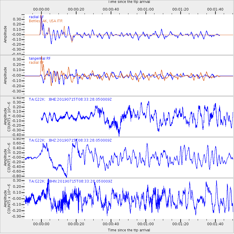
Signal To Noise
| Channel | StoN | STA | LTA |
| TA:G22K: :BHZ:20190715T08:33:28.050009Z | 7.796817 | 3.9709255E-7 | 5.0930087E-8 |
| TA:G22K: :BHN:20190715T08:33:28.050009Z | 2.857123 | 1.3015897E-7 | 4.5555957E-8 |
| TA:G22K: :BHE:20190715T08:33:28.050009Z | 2.6744537 | 1.3928266E-7 | 5.207892E-8 |
| Arrivals |
| Ps | 1.4 SECOND |
| PpPs | 4.5 SECOND |
| PsPs/PpSs | 5.9 SECOND |


