You are here: Home > Network List > TA - USArray Transportable Network (new EarthScope stations) Stations List
> Station V11A Goodsprings, NV, USA > Earthquake Result Viewer
V11A Goodsprings, NV, USA - Earthquake Result Viewer
| Earthquake location: |
Tonga Islands |
| Earthquake latitude/longitude: |
-20.1/-174.5 |
| Earthquake time(UTC): |
2007/05/27 (147) 18:12:34 GMT |
| Earthquake Depth: |
7.3 km |
| Earthquake Magnitude: |
5.8 MB, 5.1 MS, 5.6 MW, 5.5 MW |
| Earthquake Catalog/Contributor: |
WHDF/NEIC |
|
| Network: |
TA USArray Transportable Network (new EarthScope stations) |
| Station: |
V11A Goodsprings, NV, USA |
| Lat/Lon: |
35.84 N/115.43 W |
| Elevation: |
1117 m |
|
| Distance: |
78.8 deg |
| Az: |
45.28 deg |
| Baz: |
235.29 deg |
| Ray Param: |
0.049372938 |
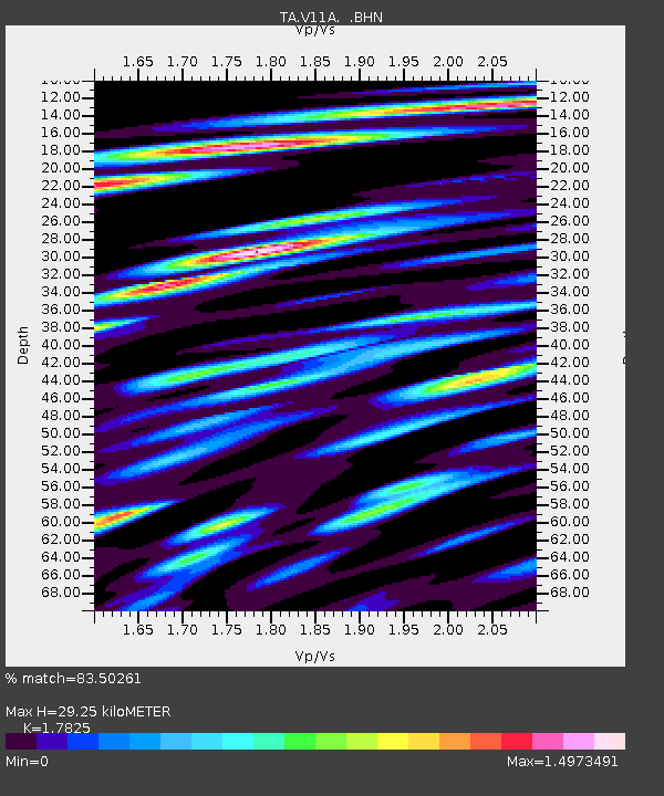
| Estimated Moho Depth: |
29.25 km |
| Estimated Crust Vp/Vs: |
1.78 |
| Assumed Crust Vp: |
6.276 km/s |
| Estimated Crust Vs: |
3.521 km/s |
| Estimated Crust Poisson's Ratio: |
0.27 |
|
| Radial Match: |
83.50261 % |
| Radial Bump: |
400 |
| Transverse Match: |
72.7519 % |
| Transverse Bump: |
400 |
| SOD ConfigId: |
2564 |
| Insert Time: |
2010-03-07 01:54:17.784 +0000 |
| GWidth: |
2.5 |
| Max Bumps: |
400 |
| Tol: |
0.001 |
|
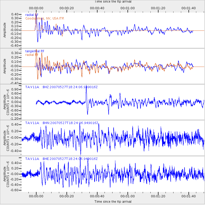
Signal To Noise
| Channel | StoN | STA | LTA |
| TA:V11A: :BHN:20070527T18:24:06.949016Z | 1.8769631 | 1.2418054E-7 | 6.6160354E-8 |
| TA:V11A: :BHE:20070527T18:24:06.949016Z | 2.7647321 | 1.758235E-7 | 6.359513E-8 |
| TA:V11A: :BHZ:20070527T18:24:06.949016Z | 5.8256483 | 4.0776635E-7 | 6.999502E-8 |
| Arrivals |
| Ps | 3.7 SECOND |
| PpPs | 13 SECOND |
| PsPs/PpSs | 16 SECOND |


