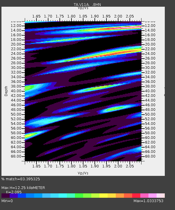
V11A Goodsprings, NV, USA - Earthquake Result Viewer
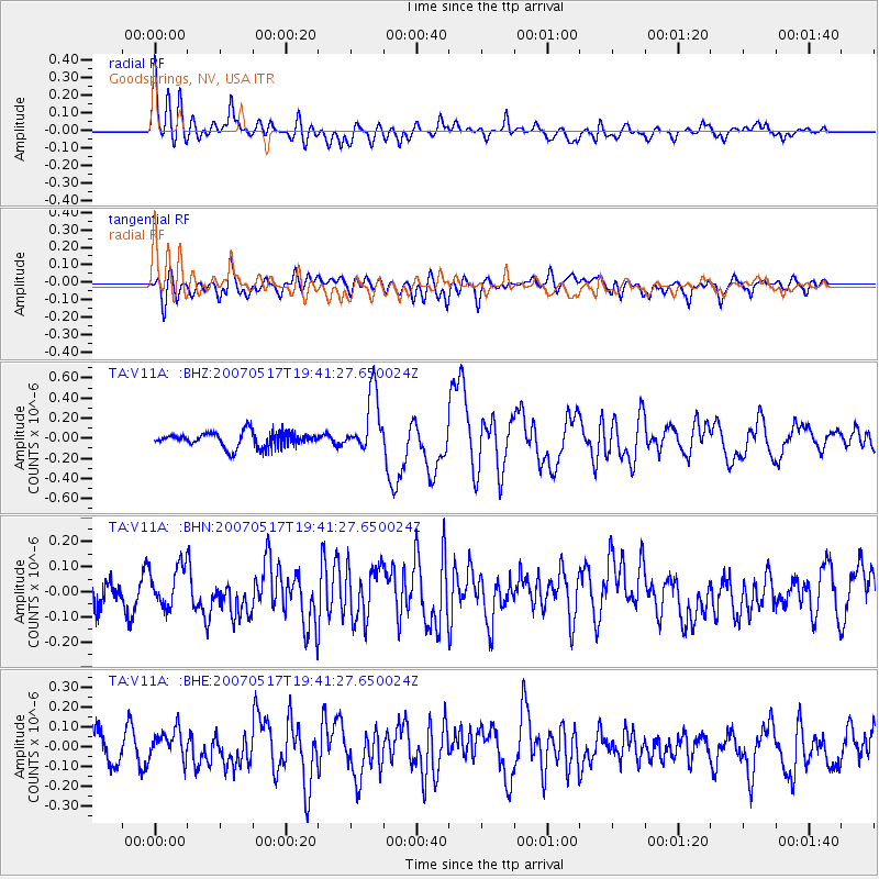
Earthquake location: Kermadec Islands, New Zealand
Earthquake latitude/longitude: -30.7/-178.2
Earthquake time(UTC): 2007/05/17 (137) 19:29:10 GMT
Earthquake Depth: 41 km
Earthquake Magnitude: 5.5 MB, 5.6 MS, 6.0 MW, 5.9 MW
Earthquake Catalog/Contributor: WHDF/NEIC
Network: TA USArray Transportable Network (new EarthScope stations)
Station: V11A Goodsprings, NV, USA
Lat/Lon: 35.84 N/115.43 W
Elevation: 1117 m
Distance: 88.6 deg
Az: 46.279 deg
Baz: 230.038 deg
Ray Param: 0.04241278
Estimated Moho Depth: 12.25 km
Estimated Crust Vp/Vs: 2.10
Assumed Crust Vp: 6.276 km/s
Estimated Crust Vs: 2.996 km/s
Estimated Crust Poisson's Ratio: 0.35
Radial Match: 83.395325 %
Radial Bump: 400
Transverse Match: 66.50263 %
Transverse Bump: 400
SOD ConfigId: 2564
Insert Time: 2010-03-07 01:54:21.531 +0000
GWidth: 2.5
Max Bumps: 400
Tol: 0.001

Signal To Noise

ChannelStoNSTALTA
TA:V11A: :BHN:20070517T19:41:27.650024Z1.78428597.9450885E-84.452811E-8
TA:V11A: :BHE:20070517T19:41:27.650024Z1.03060657.316885E-87.099591E-8
TA:V11A: :BHZ:20070517T19:41:27.650024Z4.06436822.982426E-77.3379816E-8
Arrivals
Ps2.2 SECOND
PpPs5.9 SECOND
PsPs/PpSs8.1 SECOND