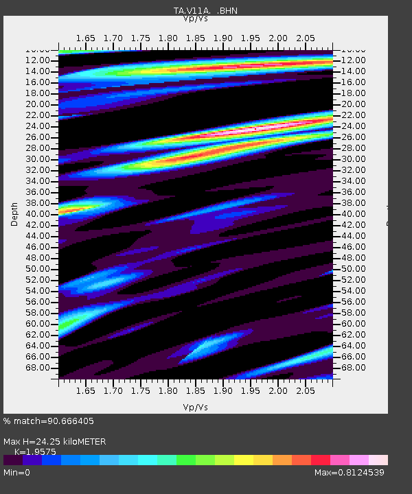
V11A Goodsprings, NV, USA - Earthquake Result Viewer
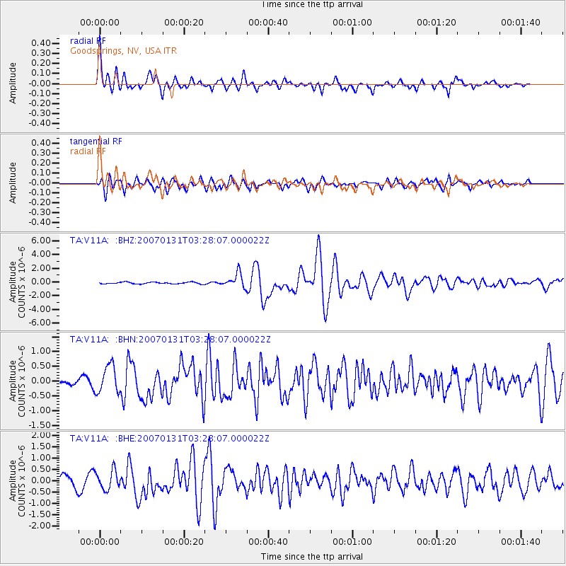
Earthquake location: Kermadec Islands, New Zealand
Earthquake latitude/longitude: -29.8/-178.0
Earthquake time(UTC): 2007/01/31 (031) 03:15:52 GMT
Earthquake Depth: 34 km
Earthquake Magnitude: 6.1 MB, 6.3 MS, 6.5 MW, 6.4 MW
Earthquake Catalog/Contributor: WHDF/NEIC
Network: TA USArray Transportable Network (new EarthScope stations)
Station: V11A Goodsprings, NV, USA
Lat/Lon: 35.84 N/115.43 W
Elevation: 1117 m
Distance: 87.9 deg
Az: 46.195 deg
Baz: 230.553 deg
Ray Param: 0.04297347
Estimated Moho Depth: 24.25 km
Estimated Crust Vp/Vs: 1.96
Assumed Crust Vp: 6.276 km/s
Estimated Crust Vs: 3.206 km/s
Estimated Crust Poisson's Ratio: 0.32
Radial Match: 90.666405 %
Radial Bump: 400
Transverse Match: 73.822845 %
Transverse Bump: 400
SOD ConfigId: 2564
Insert Time: 2010-03-07 01:54:31.559 +0000
GWidth: 2.5
Max Bumps: 400
Tol: 0.001

Signal To Noise

ChannelStoNSTALTA
TA:V11A: :BHN:20070131T03:28:07.000022Z4.993264.7405163E-79.493831E-8
TA:V11A: :BHE:20070131T03:28:07.000022Z1.99644244.1487053E-72.078049E-7
TA:V11A: :BHZ:20070131T03:28:07.000022Z8.5386081.0697931E-61.2528895E-7
Arrivals
Ps3.8 SECOND
PpPs11 SECOND
PsPs/PpSs15 SECOND