You are here: Home > Network List > TA - USArray Transportable Network (new EarthScope stations) Stations List
> Station V11A Goodsprings, NV, USA > Earthquake Result Viewer
V11A Goodsprings, NV, USA - Earthquake Result Viewer
| Earthquake location: |
East Of Kuril Islands |
| Earthquake latitude/longitude: |
46.2/154.5 |
| Earthquake time(UTC): |
2007/01/13 (013) 04:23:21 GMT |
| Earthquake Depth: |
10 km |
| Earthquake Magnitude: |
7.3 MB, 8.2 MS, 8.1 MW, 7.9 MW |
| Earthquake Catalog/Contributor: |
WHDF/NEIC |
|
| Network: |
TA USArray Transportable Network (new EarthScope stations) |
| Station: |
V11A Goodsprings, NV, USA |
| Lat/Lon: |
35.84 N/115.43 W |
| Elevation: |
1117 m |
|
| Distance: |
65.2 deg |
| Az: |
63.505 deg |
| Baz: |
310.143 deg |
| Ray Param: |
0.05841879 |
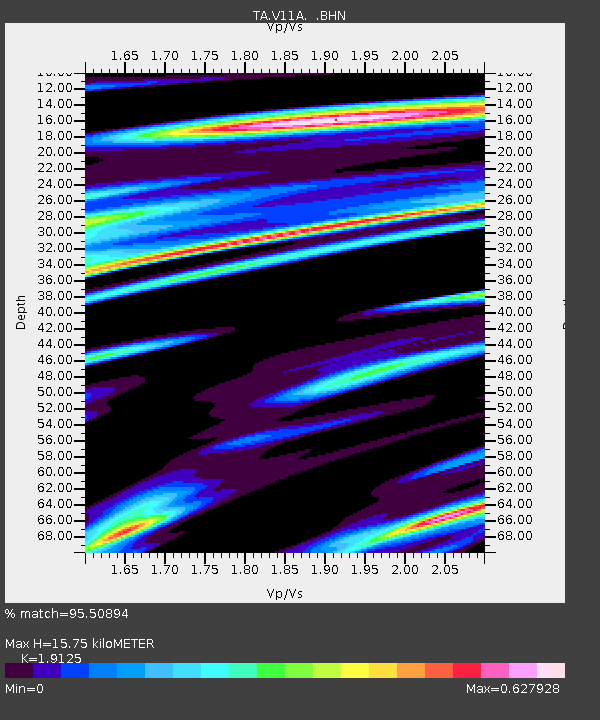
| Estimated Moho Depth: |
15.75 km |
| Estimated Crust Vp/Vs: |
1.91 |
| Assumed Crust Vp: |
6.276 km/s |
| Estimated Crust Vs: |
3.281 km/s |
| Estimated Crust Poisson's Ratio: |
0.31 |
|
| Radial Match: |
95.50894 % |
| Radial Bump: |
400 |
| Transverse Match: |
88.2084 % |
| Transverse Bump: |
400 |
| SOD ConfigId: |
2564 |
| Insert Time: |
2010-03-07 01:54:34.414 +0000 |
| GWidth: |
2.5 |
| Max Bumps: |
400 |
| Tol: |
0.001 |
|
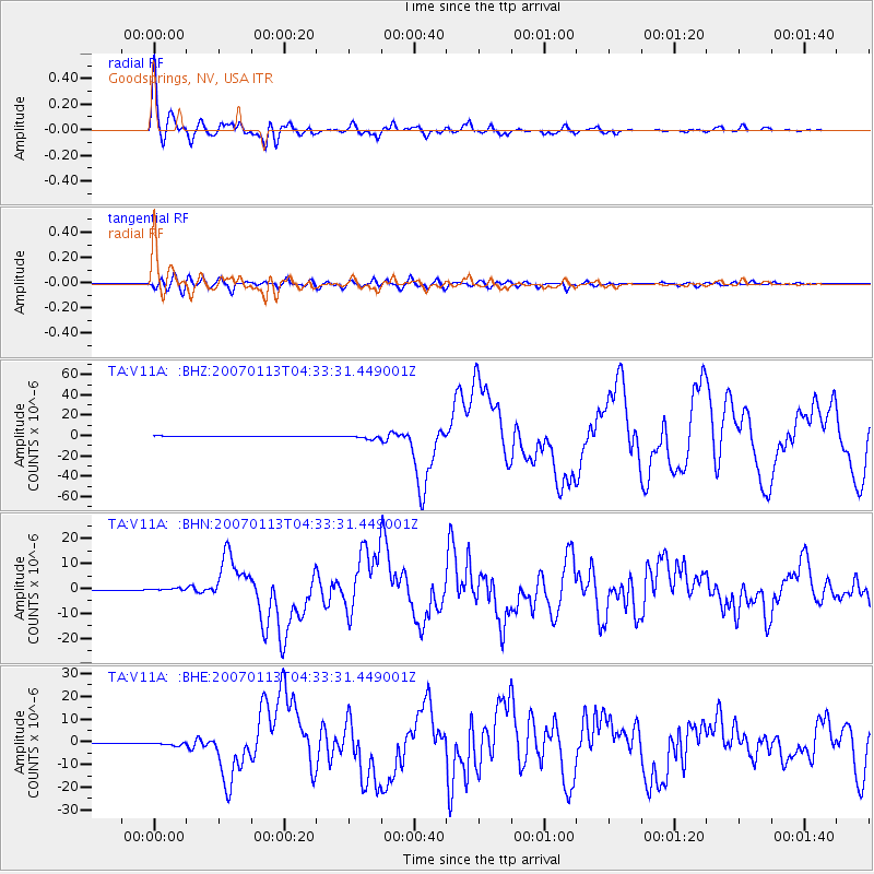
Signal To Noise
| Channel | StoN | STA | LTA |
| TA:V11A: :BHN:20070113T04:33:31.449001Z | 5.254668 | 4.6641395E-7 | 8.876182E-8 |
| TA:V11A: :BHE:20070113T04:33:31.449001Z | 5.1554713 | 7.1615085E-7 | 1.3891083E-7 |
| TA:V11A: :BHZ:20070113T04:33:31.449001Z | 8.565315 | 1.8760197E-6 | 2.1902518E-7 |
| Arrivals |
| Ps | 2.4 SECOND |
| PpPs | 7.0 SECOND |
| PsPs/PpSs | 9.4 SECOND |


